1
The Wainstones Hotel, Great Broughton
Image: © JThomas
Taken: 12 Nov 2011
0.04 miles
2
The Bay Horse, Great Broughton
Image: © Maigheach-gheal
Taken: 10 Jul 2007
0.08 miles
3
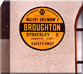
Old circular AA sign on Ingleby Road, Great Broughton
Old AA Sign located on the south facing wall of the village hall on the northeast side of a crossroads of Ingleby Road and the B1257 High Street, Great Broughton, 2 miles southeast of Stokesley. Great and Little Broughton parish.
This is the circular, village name on black band, no Motor Union symbol or name type, dating from 1923 and showing distances Ingleby Greenhow 2 Stokesley 2 London 248½.
There were five series of AA signs, mostly dating from 1923 and made by Francis & Co / Franco in Deptford, London. The village name and distance to London or Dublin were normally displayed.
See also https://www.flickr.com/photos/11065676@N00/5870151826 and https://www.geograph.org.uk/photo/1640515.
Milestone Society National ID: YO-GTBROU
Image: © Milestone Society
Taken: Unknown
0.10 miles
4
Old circular AA sign on Ingleby Road, Great Broughton
Old AA Sign located on the south facing wall of the village hall on the northeast side of a crossroads of Ingleby Road and the B1257 High Street, Great Broughton, 2 miles southeast of Stokesley. Great and Little Broughton parish.
This is the circular, village name on black band, no Motor Union symbol or name type, dating from 1923 and showing distances Ingleby Greenhow 2 Stokesley 2 London 248½.
There were five series of AA signs, mostly dating from 1923 and made by Francis & Co / Franco in Deptford, London. The village name and distance to London or Dublin were normally displayed.
See also https://www.geograph.org.uk/photo/6076740 , https://www.flickr.com/photos/11065676@N00/5870151826 and https://www.geograph.org.uk/photo/1640515.
Milestone Society National ID: YO-GTBROU
Image: © M Rayner
Taken: 6 May 2016
0.10 miles
5
Village hall, Great Broughton
The village hall in Great Broughton occupies a prominent position near the mini-roundabout at the junction of the B1257 road (straight ahead) and the minor road that runs between Kirkby (to the left) and Ingleby Greenhow (to the right). The Wainstones Hotel is located about 100 yards beyond the village hall on the right-hand side of the road.
Image: © Philip Barker
Taken: 17 Jan 2008
0.11 miles
6
Great Broughton, Methodist Church
This Church is south east of centre of the O/S grid which it occupies, on the western side of the B1257.
Image: © Bill Henderson
Taken: Unknown
0.11 miles
7
Village Hall and Crossroads, Great Broughton
In 1729 William Parkin was sentenced to death at York assizes for the murder of his brother-in-law, Anthony Noble, in a close near to Great Broughton. On his way back from York his escort rested at the Three Tuns in Stokesley where Parkin ate a "hearty dinner of beafsteaks and potatoes". He was then taken through Broughton and hanged and gibbetted. The gibbet must have been somewhere along the Ingleby road as it could be seen from Ingleby Manor. The Foulis family there had it removed.
Image: © Mick Garratt
Taken: 5 Jul 2005
0.11 miles
8
AA Sign, Great Broughton Village Hall
Close up of sign on village hall see photo http://www.geograph.org.uk/photo/24117 Not an original. It's a replica purchased by the parish council a few years ago. The original being badly rusted.
Image: © Mick Garratt
Taken: 5 Jul 2005
0.11 miles
9
Direction Sign - Signpost by the B1257, High Street, Great Broughton
Annulus finial - 4 arms; by the B1257, in parish of Great and Little Broughton (Hambleton District), Great Broughton, junction of High Street, Ingleby Road and Kirkby Lane, on big grass area Southwest of junction.
Surveyed
Milestone Society National ID: YN_NZ5406
Image: © Milestone Society
Taken: Unknown
0.12 miles
10
Ordnance Survey Cut Bench Mark
This Ordnance Survey mark was used as part of the levelling process for the OS map of 1950. The height recorded was 307.20ft above the mean sea level at Newlyn.
Image: © Michael Rye
Taken: 7 Jun 2017
0.18 miles


