IMAGES TAKEN NEAR TO
Little Ayton Lane, MIDDLESBROUGH, TS9 6HU
Introduction
This page details the photographs taken nearby to Little Ayton Lane, TS9 6HU by members of the Geograph project.
The Geograph project started in 2005 with the aim of publishing, organising and preserving representative images for every square kilometre of Great Britain, Ireland and the Isle of Man.

There are currently over 7.5m images from over14,400 individuals and you can help contribute to the project by visiting https://www.geograph.org.uk
Image Map
Images are licensed for reuse under creativecommons.org/licenses/by-sa/2.0
Notes
- Clicking on the map will re-center to the selected point.
- The higher the marker number, the further away the image location is from the centre of the postcode.
Image Listing (107 Images Found)
Images are licensed for reuse under creativecommons.org/licenses/by-sa/2.0
Image
Details
Distance
1
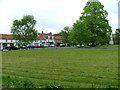
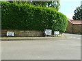
High Green, Great Ayton.
One of two greens in the village. The other being the Low Green.
Image: © Mick Garratt
Taken: 18 May 2005
0.02 miles
2

Statue of James Cook as a Boy
James Cook lived and received his basic education in Great Ayton before navigating the world. This statue, unveiled in May 1997, can be seen on the High Green and is supposed to represent James Cook walking away from the school where he was a pupil. The sculptor was Nicholas Dimbleby, brother of Jonathon and David Dimbleby and who has local connections.
It looks like it has become a popular perch by local rooks.
Image: © Mick Garratt
Taken: 2 Jul 2005
0.02 miles
3
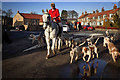
?The unspeakable in pursuit of the uneatable!?
So said Oscar Wilde about fox hunting.
My run this morning coincided with the annual Boxing Day hunt from the village green. So in anticipation of a controversial photo or two I tagged along but gave up from shear boredom after an hour during which the hunt were still only a mile or so from the village.
Although the Hunting Act 2004 banned fox hunting in England comments by leading Conservatives have energised supporters into believing the act will soon be repealed. Andrea Leadsom, the Secretary of State for Environment, Food and Rural Affairs, said during her Tory Party leadership campaign she would bring back fox hunting to improve animal welfare. David Cameron, in last year’s Conservative election manifesto, had promised a free vote on repealing of the Act and Theresa May has confirmed she is planning to push ahead with such a vote. All this is in spite of the fact that 84 per cent of the public believe fox hunting should not be made legal again.
Back in Great Ayton the pageant set off for their day’s “hunting”. This should take the form of either drag or trail hunting. Both involves the laying of an artificial trail but in one the huntsmen don’t know where the trail goes so have no means of knowing whether the hounds have picked up the artificial trail or a real one. I kept contact with the riders in the vain hope that they would lead me to the action. Their strategy seemed to be to canter for 400 metres or so then stand around for twenty minutes. 65 minutes later we were only at Monument Mine. Boredom was rapidly setting in.
The hounds meanwhile were down in Easby Wood. A lot of barking and horns sounding but no sign of them picking up a scent. If a trail had been laid it was a pretty poor job, surely someone knew where the start was.
I did attract the attention of a couple of redcoats on big intimidating horses who rode uncomfortably close. Perhaps they knew I wasn’t a proper hunt monitor and were waiting for me to give up. Tally ho.
Image: © Mick Garratt
Taken: 26 Dec 2016
0.03 miles
4
School Mill Dam
Ayton once had three mills. Most visitors are familiar with the lower weir Image This is the one providing power to the School Mill higher upstream. In times of low flow in the River Leven there was some animosity between the mill owners.
Image: © Mick Garratt
Taken: 25 Oct 2007
0.03 miles
5
Road Junction And Old Sign
Old Pre-Worboys Station Road sign at a road junction Little Ayton, North Yorkshire. For close up view see http://www.geograph.org.uk/photo/1332037
Image: © Keith Evans
Taken: 28 May 2009
0.03 miles
6
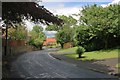
Dykes Lane
Or to use its more modern name Station Road. The building in the distance is one of the houses of the Friends School site. To the right is the site of the former Great Ayton gas works.
Image: © Mick Garratt
Taken: 27 Jun 2007
0.04 miles
7
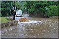
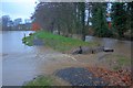
Floods, Station Road
Summer flooding on Station Road or Dykes Lane as it used to be known before the railway was built. Dykes Lane was the ancient drove road for the driving of cattle onto the moors.
Dykes Beck which runs alongside the lane for much of its length is actually culverted under the road for this section. The fountain is the effect of the water pressure in the culverted beck.
Image: © Mick Garratt
Taken: 17 Jul 2009
0.04 miles
8
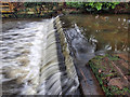
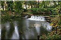
Heselton?s Mill Weir
Great Ayton had three mills. Two, Ayton Mill and Low Mill, were mediaeval corn mills and used the same weir and race to provide a head of water. A third mill, Heselton’s, was built with its own weir upstream in the late 18c originally as a linen mill for spinning. At first all was well but when Heselton’s Mill converted to milling linseed for oil in 1803 a dispute occurred. It seems that oil milling required a greater flow of water than spinning so water was dammed up at the weir released at intervals to provide the power. Of course the mills downstream suffered from this intermittent flow.
From https://fhithich.wordpress.com/2016/01/12/heseltons-mill-weir/
Image: © Mick Garratt
Taken: 12 Jan 2016
0.05 miles