IMAGES TAKEN NEAR TO
Stokesley, MIDDLESBROUGH, TS9 5LD
Introduction
This page details the photographs taken nearby to TS9 5LD by members of the Geograph project.
The Geograph project started in 2005 with the aim of publishing, organising and preserving representative images for every square kilometre of Great Britain, Ireland and the Isle of Man.

There are currently over 7.5m images from over14,400 individuals and you can help contribute to the project by visiting https://www.geograph.org.uk
Image Map
Images are licensed for reuse under creativecommons.org/licenses/by-sa/2.0
Notes
- Clicking on the map will re-center to the selected point.
- The higher the marker number, the further away the image location is from the centre of the postcode.
Image Listing (9 Images Found)
Images are licensed for reuse under creativecommons.org/licenses/by-sa/2.0
Image
Details
Distance
1
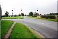
Road junction near Bense Bridge Farm
This photograph shows a view of one of the two road junctions (in the proximity of Bense Bridge Farm) formed by the intersection of the B1365 and A172 roads near Stokesley. The picture was taken looking in a south-south-westerly direction towards the A172 road.
Image: © Philip Barker
Taken: 8 Oct 2010
0.10 miles
3
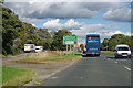
Layby on A172
Just before the Stokesley bypass and the old road through the village part company.
Image: © Robin Webster
Taken: 7 Oct 2011
0.16 miles
5
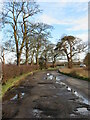
A172 lay-by
One of several such lay-bys on the A172 between the junction with A19 and Stokesley roundabout. The road appears to have been improved, possibly in the late 1950's, with bends being straightened thus leaving odd bits of old road like this potholed example.
Image: © Gordon Hatton
Taken: 20 Dec 2020
0.18 miles
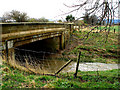
6

A172 crosses the River Leven
The willow trees betray the presence of water.
Image: © Robin Webster
Taken: 7 Oct 2011
0.19 miles
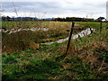
7
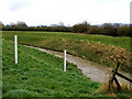
Flood height markers on the bank of the Leven
Image: © Carol Rose
Taken: 6 Apr 2008
0.19 miles
8

Eller Beck Used as Part of Stokesley Flood Defence Scheme
Before the defences were constructed the River Leven regularly flooded nearby Stokesley.
Image: © Mick Garratt
Taken: 20 Aug 2005
0.19 miles
9
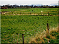
Fenced off flood levees at the side of the Leven
Image: © Carol Rose
Taken: 6 Apr 2008
0.22 miles