IMAGES TAKEN NEAR TO
High Gill Road, MIDDLESBROUGH, TS7 0DZ
Introduction
This page details the photographs taken nearby to High Gill Road, TS7 0DZ by members of the Geograph project.
The Geograph project started in 2005 with the aim of publishing, organising and preserving representative images for every square kilometre of Great Britain, Ireland and the Isle of Man.

There are currently over 7.5m images from over14,400 individuals and you can help contribute to the project by visiting https://www.geograph.org.uk
Image Map
Images are licensed for reuse under creativecommons.org/licenses/by-sa/2.0
Notes
- Clicking on the map will re-center to the selected point.
- The higher the marker number, the further away the image location is from the centre of the postcode.
Image Listing (14 Images Found)
Images are licensed for reuse under creativecommons.org/licenses/by-sa/2.0
Image
Details
Distance
1
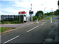
Gypsy Lane Crossing
This crossing was the cause of a lot of controversy before it was closed to traffic. Some residents of Gypsy Lane had complained about the road being used as a rat run. Others then objected to having to make a two mile detour.
The Gypsy lane residents won.
The railway marks the parish boundary between Nunthorpe and Ormesby and these parishes spelt the name Gypsy Lane differently. The Ormesby side spelt it with an 'i': Gipsy Lane. Officialdom has now caused this little peculiarity to be consigned to history.
Image: © Mick Garratt
Taken: 26 Aug 2005
0.07 miles
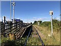
3

Gypsy Lane railway station, Yorkshire
Opened in 1976 by British Rail on its line from Middlesbrough to Whitby via Battersby. View north west towards Marton and Middlesbrough.
Image: © Nigel Thompson
Taken: 10 Oct 2009
0.09 miles
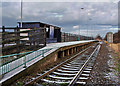
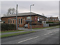
4
Gypsy Lane Railway Station
Served by services on the Middlesbrough - Whitby line, and by some Durham Coast Line services that are extended beyond Middlesbrough to Nunthorpe or Battersby.
Image: © David Robinson
Taken: 20 Sep 2021
0.10 miles
5
Gypsy Lane Station
On the Whitby to Middlesbrough line.
Image: © Stephen McCulloch
Taken: 5 Jan 2009
0.10 miles
6
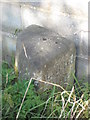
Old Boundary Marker
Parish Boundary Marker 30 metres north of 9A Gypsy Lane, Nunthorpe, Middlesbrough, against and outside the garden wall of another house. This was on the boundary of Marton and Ormesby parishes but is now entirely in an unparished area of Redcar and Cleveland borough. Inscribed MARTON WEST C.P. Grade II Listed https://historicengland.org.uk/listing/the-list/list-entry/1139632.
Milestone Society National ID: YN_REDC01pb
Image: © Mike Rayner
Taken: 24 Aug 2019
0.11 miles
7
St Bernadette's RC church
On Gypsy Lane.
Image: © Stephen McCulloch
Taken: 10 Dec 2008
0.11 miles
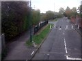
9
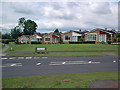
Row of Bungalows
On the corner of Cypress Road and Gypsy Lane
Image: © Stephen McCulloch
Taken: 26 Jun 2007
0.18 miles
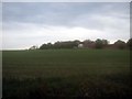
10
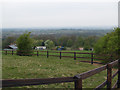
Pasture land, Hambleton Hill
No horses out today.
Image: © Stephen McCulloch
Taken: 24 Apr 2008
0.21 miles