IMAGES TAKEN NEAR TO
Cresswell Road, MIDDLESBROUGH, TS6 7EN
Introduction
This page details the photographs taken nearby to Cresswell Road, TS6 7EN by members of the Geograph project.
The Geograph project started in 2005 with the aim of publishing, organising and preserving representative images for every square kilometre of Great Britain, Ireland and the Isle of Man.

There are currently over 7.5m images from over14,400 individuals and you can help contribute to the project by visiting https://www.geograph.org.uk
Image Map
Images are licensed for reuse under creativecommons.org/licenses/by-sa/2.0
Notes
- Clicking on the map will re-center to the selected point.
- The higher the marker number, the further away the image location is from the centre of the postcode.
Image Listing (14 Images Found)
Images are licensed for reuse under creativecommons.org/licenses/by-sa/2.0
Image
Details
Distance
1
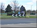
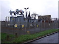
Roundabout on the A66/Tees Dock Road (A1053)
There appears to be some sort of industrial artefacts adorning the roundabout but it is not clear what they are.
Image: © Oliver Dixon
Taken: 21 Mar 2017
0.07 miles
2
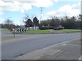
Roundabout on Tees Dock Road (A1053)/A66
There appears to be some sort of industrial artefacts adorning the roundabout but it is not clear what they are.
Image: © Oliver Dixon
Taken: 21 Mar 2017
0.08 miles
3
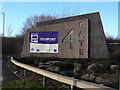
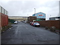
4 GATE
Entrance to Teesport off the A66 at Grangetown.
Image: © Alan Murray-Rust
Taken: 9 Feb 2010
0.10 miles
5
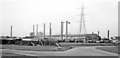
Steelworks in South Bank - Grangetown area, 1961
View believed to be NW from Tees Dock Road, near Grangetown station, but - [There has been so much change here in the ensuing 50-60 years, that locating this scene at all precisely is very difficult!]
Image: © Ben Brooksbank
Taken: 19 Apr 1961
0.12 miles
7
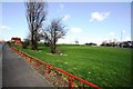
Grassland area in Grangetown
This photograph shows a view of one of the fabricated grassland areas in the Grangetown area of Teesside. The A1085 road can be seen in the right-hand side of the image. The picture was taken looking in a north-north-easterly direction towards Teesside Works, Lackenby.
Image: © Philip Barker
Taken: 1 Apr 2010
0.14 miles
8
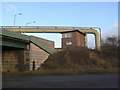
Old signal cabin
Formerly serving a part of the steelworks railway network rendered redundant by the closure of the South Bank works.
Image: © Alan Murray-Rust
Taken: 9 Feb 2010
0.16 miles
9
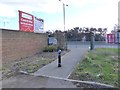
Cyclist and pedestrian cut-through
Leading from Lee Road, Grangetown onto the A66.
Image: © Oliver Dixon
Taken: 21 Mar 2017
0.17 miles
10
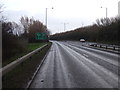
Lee Road looking north
Now bisected by the A66.
Image: © JThomas
Taken: 25 Jan 2014
0.19 miles