IMAGES TAKEN NEAR TO
Farley Drive, MIDDLESBROUGH, TS5 8QT
Introduction
This page details the photographs taken nearby to Farley Drive, TS5 8QT by members of the Geograph project.
The Geograph project started in 2005 with the aim of publishing, organising and preserving representative images for every square kilometre of Great Britain, Ireland and the Isle of Man.

There are currently over 7.5m images from over14,400 individuals and you can help contribute to the project by visiting https://www.geograph.org.uk
Image Map
Images are licensed for reuse under creativecommons.org/licenses/by-sa/2.0
Notes
- Clicking on the map will re-center to the selected point.
- The higher the marker number, the further away the image location is from the centre of the postcode.
Image Listing (5 Images Found)
Images are licensed for reuse under creativecommons.org/licenses/by-sa/2.0
Image
Details
Distance
1
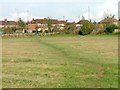
Open Space, Whinney Banks
Public open land created along the east bank of Blue Bell Beck between the Whinney Banks housing estate and the A19. In the photo a footpath formed through use leads from the car parking facility.
Image: © Mick Garratt
Taken: 17 Nov 2005
0.12 miles
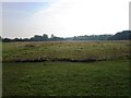
3

Footbridge, Blue Bell Beck, Whinney Banks
Image: © Mick Garratt
Taken: 17 Nov 2005
0.18 miles
5
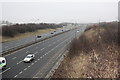
Traffic on the A19(T) road
This photograph shows a view of the traffic on a section of the A19(T) road near the Whinney Banks interchange. The road bridge that can be can be seen in the distance carries the A1130 road over the dual carriageway. This picture was taken from the access bridge to Stainsby Hill Farm looking in a north-north-easterly direction towards the River Tees.
Image: © Philip Barker
Taken: 17 Feb 2010
0.22 miles