IMAGES TAKEN NEAR TO
Beadon Grove, MIDDLESBROUGH, TS5 4NT
Introduction
This page details the photographs taken nearby to Beadon Grove, TS5 4NT by members of the Geograph project.
The Geograph project started in 2005 with the aim of publishing, organising and preserving representative images for every square kilometre of Great Britain, Ireland and the Isle of Man.

There are currently over 7.5m images from over14,400 individuals and you can help contribute to the project by visiting https://www.geograph.org.uk
Image Map (Loading...)


Getting Data...Please wait
Leaflet Map data © OpenStreetMap
Images are licensed for reuse under creativecommons.org/licenses/by-sa/2.0
Notes
- Clicking on the map will re-center to the selected point.
- The higher the marker number, the further away the image location is from the centre of the postcode.
Image Listing (10 Images Found)
Images are licensed for reuse under creativecommons.org/licenses/by-sa/2.0
Image
Details
Distance
2
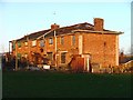
Derelict Housing, Whinney Banks
The whole area is being developed into a mixed residential of privately owned and affordable housing.
Image: © Mick Garratt
Taken: 20 Jan 2006
0.03 miles


9
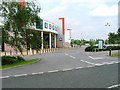
Teesside Park
Bowling, multiplex cinema, a nightclub, fast food outlets and of course bingo are all available on this leisure complex.
Image: © Mick Garratt
Taken: 15 Jun 2005
0.24 miles
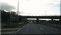
10
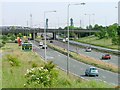
Major Interchange between the A66 and the A19
Looking north along the A19. In the distance can be seen the two piers of the Newport Bridge.
Image: © Mick Garratt
Taken: 15 Jun 2005
0.24 miles