IMAGES TAKEN NEAR TO
The Ladle, MIDDLESBROUGH, TS4 3SL
Introduction
This page details the photographs taken nearby to The Ladle, TS4 3SL by members of the Geograph project.
The Geograph project started in 2005 with the aim of publishing, organising and preserving representative images for every square kilometre of Great Britain, Ireland and the Isle of Man.

There are currently over 7.5m images from over14,400 individuals and you can help contribute to the project by visiting https://www.geograph.org.uk
Image Map (Loading...)


Getting Data...Please wait
Leaflet Map data © OpenStreetMap
Images are licensed for reuse under creativecommons.org/licenses/by-sa/2.0
Notes
- Clicking on the map will re-center to the selected point.
- The higher the marker number, the further away the image location is from the centre of the postcode.
Image Listing (12 Images Found)
Images are licensed for reuse under creativecommons.org/licenses/by-sa/2.0
Image
Details
Distance
1
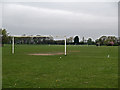
Prissick playing fields
Viewed from Ladgate Lane
Image: © Stephen McCulloch
Taken: 24 Apr 2008
0.04 miles
4
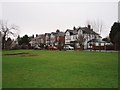
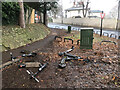
Park area near Marton Avenue
This photograph shows a view of a small park near Marton Avenue. Some of the houses in Marton Avenue can be seen in the centre of the picture. The consequences of a bonfire night celebration in November can be seen in the left-hand side of the grassed area. The picture was taken looking in a southerly direction towards Stewart Park.
Image: © Philip Barker
Taken: 2 Feb 2010
0.15 miles
5
Ginger Scooter Parking Location
See https://www.ginger.town/middlesbrough
Image: © Mick Garratt
Taken: 15 Jan 2022
0.18 miles
6
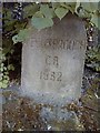
Old Boundary Marker
Municipal Boundary Marker on the east side of The Grove outside number 100. On the former boundary of Marton and Ormesby, now Middlesbrough and Redcar unitary authorities. Inscribed MIDDLESBROUGH / C.B. / 1932.
Milestone Society National ID: YN_MIDRED01pb
Image: © A Cairns
Taken: 2 Jun 2020
0.18 miles
7
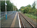
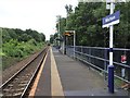
Marton railway station, Yorkshire, 2009
Opened in 1854 by the Middlesbrough & Guisborough Railway on what is today the line from Middlesbrough to Whitby, this station was called 'Ormesby' until 1982.
View north west towards Middlesbrough. The line was double track until 1986, with a southbound track and platform to the far right. No trace remains.
A waiting shelter and information screen were added around 5 years after this image was taken. See Image for a 2019 view in the opposite direction.
Image: © Nigel Thompson
Taken: 10 Oct 2009
0.20 miles
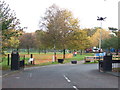
8
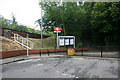
Marton railway station entrance and car park
Image: © Adam Brookes
Taken: 11 Jun 2009
0.20 miles
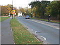
9
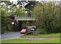
Railway bridge over Ladgate Lane
By Marton station.
Image: © Stephen McCulloch
Taken: 24 Apr 2008
0.21 miles
10
Marton railway station, Yorkshire
Opened in 1854 by the Middlesbrough & Guisborough Railway on what is today the line from Middlesbrough to Whitby, this station was called 'Ormesby' until 1982.
View south east towards Gypsy Lane and Whitby. The line was double track until 1986, with a southbound track and platform to the far left. No trace remains.
A waiting shelter and information screen has been added since Image was taken 10 years earlier.
Image: © Nigel Thompson
Taken: 29 Jul 2019
0.21 miles