IMAGES TAKEN NEAR TO
Ainderby Way, MIDDLESBROUGH, TS4 3BY
Introduction
This page details the photographs taken nearby to Ainderby Way, TS4 3BY by members of the Geograph project.
The Geograph project started in 2005 with the aim of publishing, organising and preserving representative images for every square kilometre of Great Britain, Ireland and the Isle of Man.

There are currently over 7.5m images from over14,400 individuals and you can help contribute to the project by visiting https://www.geograph.org.uk
Image Map
Images are licensed for reuse under creativecommons.org/licenses/by-sa/2.0
Notes
- Clicking on the map will re-center to the selected point.
- The higher the marker number, the further away the image location is from the centre of the postcode.
Image Listing (15 Images Found)
Images are licensed for reuse under creativecommons.org/licenses/by-sa/2.0
Image
Details
Distance
1
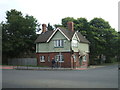
North Lodge - Marton Road
Former entrance lodge to Cleveland Asylum later St Luke's Hospital. The asylum opened in 1898.
Image: © John M
Taken: 19 Aug 2013
0.05 miles
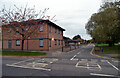
2
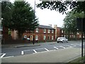
Housing - Marton Burn Road (2 of 2)
An early example of post WW1 housing.
Image: © John M
Taken: 19 Aug 2013
0.15 miles
3
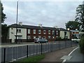
Housing - Marton Burn Road (1 of 2)
Probably an early design of post WW1 housing.
Image: © John M
Taken: 19 Aug 2013
0.15 miles
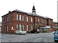
4
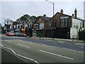
Shops on Marton Road
The brickwork shows a date of 1909.
Image: © John M
Taken: 19 Aug 2013
0.15 miles
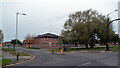
5
St. Luke's Hospital
Apparently due for replacement in 2009 but the clock tower will remain.
Image: © Mick Garratt
Taken: 9 Oct 2005
0.17 miles
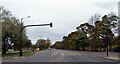
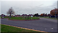
6
Martonside Way seen from Marton Way, Middlesbrough
Image: © habiloid
Taken: 30 Oct 2021
0.17 miles
8
The junction of Marton Way and Marton Road (A172), Middlesbrough
Image: © habiloid
Taken: 30 Oct 2021
0.19 miles
9
Cavendish Road seen from Marton Way, Middlesbrough
Image: © habiloid
Taken: 30 Oct 2021
0.20 miles
10
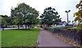
Pavement, Marton Road (A172), Middlesbrough
Image: © habiloid
Taken: 30 Oct 2021
0.21 miles