IMAGES TAKEN NEAR TO
Bank Top, TRIMDON STATION, TS29 6QN
Introduction
This page details the photographs taken nearby to Bank Top, TS29 6QN by members of the Geograph project.
The Geograph project started in 2005 with the aim of publishing, organising and preserving representative images for every square kilometre of Great Britain, Ireland and the Isle of Man.

There are currently over 7.5m images from over14,400 individuals and you can help contribute to the project by visiting https://www.geograph.org.uk
Image Map
Images are licensed for reuse under creativecommons.org/licenses/by-sa/2.0
Notes
- Clicking on the map will re-center to the selected point.
- The higher the marker number, the further away the image location is from the centre of the postcode.
Image Listing (15 Images Found)
Images are licensed for reuse under creativecommons.org/licenses/by-sa/2.0
Image
Details
Distance
1
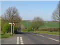
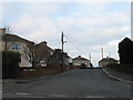
Salter's Lane, near Trimdon
Salter's Hill descends a steep gradient as it heads north from Trimdon towards Trimdon Grange.
Image: © Malc McDonald
Taken: 20 Apr 2019
0.03 miles
2
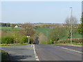
Salter's Lane, Trimdon
Salter's Lane leaving Trimdon, looking northwards towards the village of Trimdon Grange.
Image: © Malc McDonald
Taken: 20 Apr 2019
0.03 miles
3
Salter's Lane, Trimdon
Salter's Lane, heading out of the village of Trimdon in County Durham.
Image: © Malc McDonald
Taken: 20 Apr 2019
0.05 miles
4
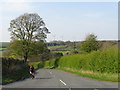
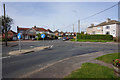
Road in the countryside near Trimdon
A minor road in County Durham countryside near the village of Trimdon.
Image: © Malc McDonald
Taken: 20 Apr 2019
0.05 miles
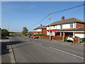
6
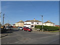
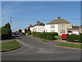
Trimdon
The village of Trimdon, known as Trimdon Village to differentiate it from Trimdon Grange, Trimdon Colliery and Trimdon Station (Deaf Hill)
Image: © David Robinson
Taken: 9 Sep 2021
0.09 miles
8
Tees View, Trimdon
Tees View in the image of Trimdon, in County Durham.
Image: © Malc McDonald
Taken: 20 Apr 2019
0.12 miles
10
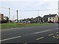
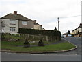
Burn Oval, Trimdon
Burn Oval is a residential cul-de-sac in the village of Trimdon in County Durham.
Image: © Malc McDonald
Taken: 20 Apr 2019
0.19 miles