IMAGES TAKEN NEAR TO
Burdon Crescent, WINGATE, TS28 5LF
Introduction
This page details the photographs taken nearby to Burdon Crescent, TS28 5LF by members of the Geograph project.
The Geograph project started in 2005 with the aim of publishing, organising and preserving representative images for every square kilometre of Great Britain, Ireland and the Isle of Man.

There are currently over 7.5m images from over14,400 individuals and you can help contribute to the project by visiting https://www.geograph.org.uk
Image Map
Images are licensed for reuse under creativecommons.org/licenses/by-sa/2.0
Notes
- Clicking on the map will re-center to the selected point.
- The higher the marker number, the further away the image location is from the centre of the postcode.
Image Listing (18 Images Found)
Images are licensed for reuse under creativecommons.org/licenses/by-sa/2.0
Image
Details
Distance
2
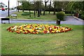
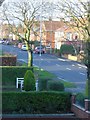
Spring flowers in Wingate
This photograph shows a view of a spring-time flower bed in the Wellfield area of Wingate. The B1280 road can be seen to the left of the floral display. The Fir Tree hostelry is just visible in the top left-hand corner of the image (above the red van) - see here Image The picture was taken looking in a northerly direction towards Edderacres Plantation.
Image: © Philip Barker
Taken: 14 May 2010
0.05 miles
5
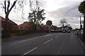
The Co-op shop, Wingate
Formerly the Fir Tree public house Image
Image: © Ian S
Taken: 12 Sep 2020
0.08 miles
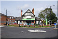
6
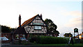
Fir Tree Pub
Situated in Wingate Co.Durham
Image: © George Ford
Taken: 10 Aug 2005
0.09 miles
7
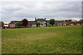
The Cloisters - Wingate
This photograph shows a view of the old A.J. Dawson's grammar school in Wingate. After it ceased functioning as a school building the premises was converted into apartments. The grassed area in the foreground of the image formed the school playing field. The picture was taken looking in a south-south-westerly direction towards Low Grange Farm.
Image: © Philip Barker
Taken: 14 May 2010
0.10 miles