IMAGES TAKEN NEAR TO
Coast Road, HARTLEPOOL, TS27 4HS
Introduction
This page details the photographs taken nearby to Coast Road, TS27 4HS by members of the Geograph project.
The Geograph project started in 2005 with the aim of publishing, organising and preserving representative images for every square kilometre of Great Britain, Ireland and the Isle of Man.

There are currently over 7.5m images from over14,400 individuals and you can help contribute to the project by visiting https://www.geograph.org.uk
Image Map
Images are licensed for reuse under creativecommons.org/licenses/by-sa/2.0
Notes
- Clicking on the map will re-center to the selected point.
- The higher the marker number, the further away the image location is from the centre of the postcode.
Image Listing (9 Images Found)
Images are licensed for reuse under creativecommons.org/licenses/by-sa/2.0
Image
Details
Distance
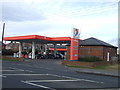
2
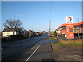
TOTAL filling station at Blackhall Colliery
This photograph shows a view of the TOTAL filling station on the A1086 at Blackhall Colliery. The photograph was taken looking in a northerly direction from Glenholme Terrace. The junction of the B1281 with the A1086 can just be seen beyond the traffic island.
Image: © Philip Barker
Taken: 17 Jan 2010
0.01 miles
4
Site of Blackhall Colliery
The main shaft was sunk in 1909 and the first coal produced in 1913. The geological conditions were difficult with water saturated strata and flooding. Blackhall became the final phase of the Durham Coalfield reaching out under the sea for approximately 3 miles and it was one of the most advanced collieries of the region. colliery from 1978 onwards. In 1981, Blackhall ceased production, 732 men were transferred to other collieries and 586 accepted redundancy. The colliery was finally closed and demolished in 1986. Much of the land was landscaped and converted into a business park. The topsoil is thin here on the layers of compacted waste and the planted trees have taken some time to become established.
Research documents relating to the Durham Coalfield can be found here http://www.durham-miner.org.uk/miner/usp.nsf/pws/Durham+Miner+Project+-+Durham+Miner+Home+Page
Image: © Andrew Curtis
Taken: 4 Dec 2009
0.17 miles
5
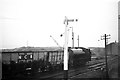
Steam locomotive at Blackhall Colliery ? 1966
Taken from a passing train.
The locomotive (unidentified) is one of the 'Austerity' type saddle tanks of which the NCB purchased considerable numbers, either second-hand from the Ministry of Defence or as post-war new build. The rather antique semaphore signal is typical of survivors on the more extensive colliery networks, which often had a rudimentary signalling system.
Image: © Alan Murray-Rust
Taken: 26 Mar 1966
0.18 miles
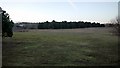
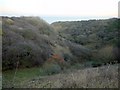
7
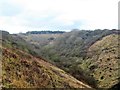
Blue House Gill
Looking inland along this steep sided little valley, the far end of which rises even more steeply to the site of the former colliery, the waste from which still blocks the head of the gill.
Image: © Gordon Hatton
Taken: 18 Mar 2019
0.22 miles
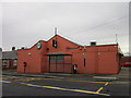
8
Old industrial site, Blackhall Colliery
The local village name echoes this site which was once part of Blackhall Colliery. Now an open access area with some tree planting and vandalised information boards.
Image: © Gordon Hatton
Taken: 18 Mar 2019
0.22 miles
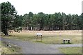
9
Blue House Gill
There's a better summer view of the Gill (in the daylight) here Image
The orange berries in the valley bottom belong to Image
Image: © Andrew Curtis
Taken: 4 Dec 2009
0.23 miles