IMAGES TAKEN NEAR TO
Buckingham Avenue, HARTLEPOOL, TS27 3BD
Introduction
This page details the photographs taken nearby to Buckingham Avenue, TS27 3BD by members of the Geograph project.
The Geograph project started in 2005 with the aim of publishing, organising and preserving representative images for every square kilometre of Great Britain, Ireland and the Isle of Man.

There are currently over 7.5m images from over14,400 individuals and you can help contribute to the project by visiting https://www.geograph.org.uk
Image Map
Images are licensed for reuse under creativecommons.org/licenses/by-sa/2.0
Notes
- Clicking on the map will re-center to the selected point.
- The higher the marker number, the further away the image location is from the centre of the postcode.
Image Listing (33 Images Found)
Images are licensed for reuse under creativecommons.org/licenses/by-sa/2.0
Image
Details
Distance
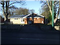
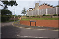
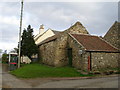
4
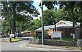
Hart village hall
Taken on general election day 2024.
Image: © Gordon Hatton
Taken: 4 Jul 2024
0.12 miles
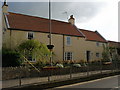
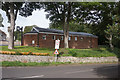
8
The stepped sides of buildings in Hart
The cream building is Holme Farm. The stone building has a handmade sign saying 'Home Farm'.
Image: © Carol Rose
Taken: 25 Apr 2007
0.15 miles
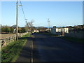
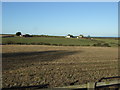
9
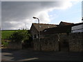
Old farm buildings to the rear of Holme Farm
The modern road to the front leads to a small modern housing estate. The green field rises up towards the Hart bypass and a wind turbine can just be seen above it.
Image: © Carol Rose
Taken: 25 Apr 2007
0.17 miles