IMAGES TAKEN NEAR TO
Colwyn Road, HARTLEPOOL, TS26 9BL
Introduction
This page details the photographs taken nearby to Colwyn Road, TS26 9BL by members of the Geograph project.
The Geograph project started in 2005 with the aim of publishing, organising and preserving representative images for every square kilometre of Great Britain, Ireland and the Isle of Man.

There are currently over 7.5m images from over14,400 individuals and you can help contribute to the project by visiting https://www.geograph.org.uk
Image Map (Loading...)


Getting Data...Please wait
Leaflet Map data © OpenStreetMap
Images are licensed for reuse under creativecommons.org/licenses/by-sa/2.0
Notes
- Clicking on the map will re-center to the selected point.
- The higher the marker number, the further away the image location is from the centre of the postcode.
Image Listing (2 Images Found)
Images are licensed for reuse under creativecommons.org/licenses/by-sa/2.0
Image
Details
Distance
1
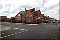
St Matthews Community Centre
This photograph shows a view of St Matthews Community Centre and the Stranton Church Parish Centre. The building is located in the north-west quadrant of the areas formed by the intersection of Elwick Road (running across the image) with Arncliffe Gardens (ahead) and Baden Street (behind the photographer). The picture was taken looking in a north-westerly direction towards Ward Jackson Park.
Image: © Philip Barker
Taken: 28 May 2010
0.08 miles
2
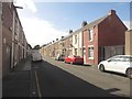
Thirlmere Street, Hartlepool
A street of terraced houses off Elwick Road. The street is one of a number of parallel rows of terraces off the south side of Elwick Road.
Image: © Graham Robson
Taken: 11 Sep 2018
0.19 miles