IMAGES TAKEN NEAR TO
Friar Terrace, HARTLEPOOL, TS24 0PF
Introduction
This page details the photographs taken nearby to Friar Terrace, TS24 0PF by members of the Geograph project.
The Geograph project started in 2005 with the aim of publishing, organising and preserving representative images for every square kilometre of Great Britain, Ireland and the Isle of Man.

There are currently over 7.5m images from over14,400 individuals and you can help contribute to the project by visiting https://www.geograph.org.uk
Image Map
Images are licensed for reuse under creativecommons.org/licenses/by-sa/2.0
Notes
- Clicking on the map will re-center to the selected point.
- The higher the marker number, the further away the image location is from the centre of the postcode.
Image Listing (219 Images Found)
Images are licensed for reuse under creativecommons.org/licenses/by-sa/2.0
Image
Details
Distance
1
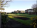
Gardens and bowling green from The Lawns, Hartlepool Headland
Image: © Andrew Curtis
Taken: 4 Dec 2009
0.03 miles
2

St. Mary's Roman Catholic Church
Durham Street. The church was built in Transitional Norman or ‘First Point Period’ in 1851 at a time when the population of Hartlepool was increasing with an influx of dock and railway workers. The church was designed by Joseph Aloysius Hansom who also designed the Hansom Cab and was paid for by weekly collections from the 1,500 parishioners in the area who also carried the stone from a nearby quarry.
Image: © Mick Garratt
Taken: 16 Nov 2007
0.04 miles
3
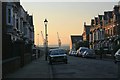
Gladstone Street
Looking down towards two of the dock cranes.
Image: © Mick Garratt
Taken: 16 Nov 2007
0.05 miles
4
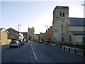
Durham Street, Hartlepool Headland
On the right is St Mary's Catholic Church Image St Hilda's Church Image can be seen further down the street.
Image: © Andrew Curtis
Taken: 4 Dec 2009
0.06 miles
5

St Mary's church, Hartlepool
The present Catholic church is rather overshadowed by its older and larger Anglican neighbour.
Image: © Stephen Craven
Taken: 23 Sep 2008
0.06 miles
6
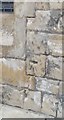
Ordnance Survey 1GL Bolt
This OS Bolt can be found on the SE face of the R.C. Church. It marks a point 14.243m above mean sea level.
Image: © Adrian Dust
Taken: 17 Sep 2018
0.07 miles
7
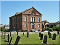
Medieval Manor House
Built in 1605 and also known as The Friary later was used as a workhouse and hospital. Now sadly neglected.
Image: © Mick Garratt
Taken: 16 Nov 2007
0.07 miles
8

Saint Mary's altar
The altar in Saint Mary's Church on the Headland.
Image: © ian malcolmson
Taken: 9 Jun 2010
0.07 miles
9
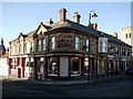
The Cosmopolitan Hotel, Hartlepool Headland
The hotel is on the corner of Durham Street and Middlegate. Another, reportedly haunted building on the spooky Headland. Paranormal activity started when alterations were made to the cellars in the 1970’s. Renovations were left half finished because workers found the atmosphere too spooky and refused to carry on digging.
Image: © Andrew Curtis
Taken: 4 Dec 2009
0.08 miles
10
Morison Hall
Now apartments but looks like a non-conformist church
Image: © Kevin Waterhouse
Taken: 15 Jun 2023
0.08 miles