IMAGES TAKEN NEAR TO
Heortnesse Road, HARTLEPOOL, TS24 0BU
Introduction
This page details the photographs taken nearby to Heortnesse Road, TS24 0BU by members of the Geograph project.
The Geograph project started in 2005 with the aim of publishing, organising and preserving representative images for every square kilometre of Great Britain, Ireland and the Isle of Man.

There are currently over 7.5m images from over14,400 individuals and you can help contribute to the project by visiting https://www.geograph.org.uk
Image Map
Images are licensed for reuse under creativecommons.org/licenses/by-sa/2.0
Notes
- Clicking on the map will re-center to the selected point.
- The higher the marker number, the further away the image location is from the centre of the postcode.
Image Listing (25 Images Found)
Images are licensed for reuse under creativecommons.org/licenses/by-sa/2.0
Image
Details
Distance
1
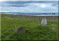
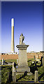
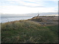
Spion Kop Cemetery
Spion Kop Cemetery, originally known as Hartlepool Cemetery, is a disused cemetery on the coast near Hartlepool. It was opened in 1856 to replace St. Hilda's churchyard and designed by John Dobson. The area took its name from the Battle of Spion Kop in 1900 during the Boer War.
The cemetery was formed from a combination of sand dune and ship's ballast. It is closed to new burials and is now managed as a local nature reserve.
In the distance is the disused Steetley Magnesite pier at North Sands.
Image: © Mat Fascione
Taken: 26 Aug 2017
0.10 miles
2
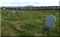
Spion Kop Cemetery
Spion Kop Cemetery, originally known as Hartlepool Cemetery, is a disused cemetery on the coast near Hartlepool. It was opened in 1856 to replace St. Hilda's churchyard and designed by John Dobson. The area took its name from the Battle of Spion Kop in 1900 during the Boer War.
The cemetery was formed from a combination of sand dune and ship's ballast. It is closed to new burials and is now managed as a local nature reserve.
Image: © Mat Fascione
Taken: 26 Aug 2017
0.10 miles
3
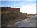
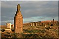
Old cemetery wall
Stands precariously on top of the dunes. The land on the right of the picture is an old industrial site.
Image: © Jonathan Thacker
Taken: 29 Nov 2012
0.10 miles
4
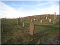
Spion Kop cemetery
In a bleak position on top of the dunes.
Image: © Jonathan Thacker
Taken: 29 Nov 2012
0.10 miles
7
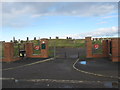
Entrance to Spion Kop Cemetery Hartlepool
Opened 1856 and now with over 26,000 burials
Image: © Peter Robinson
Taken: 7 Nov 2010
0.13 miles
8
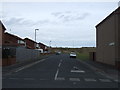
Footpath parallel to Old Cemetery Road
Follows the line of the former Hartlepool Dock and railway line opened in 1835 and finally closed in 1969.
Image: © Jonathan Thacker
Taken: 29 Nov 2012
0.15 miles
9
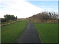
The top of the dunes
The coastline here is backed by high dunes which in the past have been developed for industrial use. Now all is dereliction.
Image: © Jonathan Thacker
Taken: 29 Nov 2012
0.17 miles
10
Spion Kop Cemetery
Or officially the Hartlepool Cemetery. Opened in 1856 and designed by John Dobson, an architect of some standing. The Spion Kop name became in use after the Boer War battle. It was in use in at least 2005 but is now designated as a nature reserve on account of its sandy nutrient poor alkaline soil producing a rich dune grassland that is unique on Teesside. The grass has just been given its annual cut .
Image: © Mick Garratt
Taken: 16 Nov 2007
0.17 miles