IMAGES TAKEN NEAR TO
Mill Lane, BILLINGHAM, TS23 1HN
Introduction
This page details the photographs taken nearby to Mill Lane, TS23 1HN by members of the Geograph project.
The Geograph project started in 2005 with the aim of publishing, organising and preserving representative images for every square kilometre of Great Britain, Ireland and the Isle of Man.

There are currently over 7.5m images from over14,400 individuals and you can help contribute to the project by visiting https://www.geograph.org.uk
Image Map
Images are licensed for reuse under creativecommons.org/licenses/by-sa/2.0
Notes
- Clicking on the map will re-center to the selected point.
- The higher the marker number, the further away the image location is from the centre of the postcode.
Image Listing (8 Images Found)
Images are licensed for reuse under creativecommons.org/licenses/by-sa/2.0
Image
Details
Distance
1
ICI Billingham, September 1970 No. 7
See Image] etc.
Image: © Ben Brooksbank
Taken: 6 Sep 1970
0.08 miles
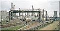
2
ICI Billingham, September 1970 No. 8
See Image] etc.
Image: © Ben Brooksbank
Taken: 6 Sep 1970
0.12 miles
3
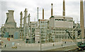
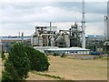
ICI Billingham, September 1970 No.9
Methanol Plant: see Image] etc.
Image: © Ben Brooksbank
Taken: 6 Sep 1970
0.16 miles
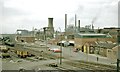
4
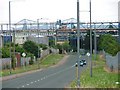
Chemical Works, Billingham
View down the public road through the middle of the various chemical works formerly operated by ICI. The site was established in 1917 when the government built a nitrate plant for use in explosives. After the war the plant was brought by Brunner Mond and converted to produce fertilisers. ICI was formed in 1926 by the merger of the four biggest chemical companies.
Image: © Mick Garratt
Taken: 18 Jul 2005
0.22 miles
6
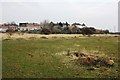
Country Park near Chilton Lane Estate
This photograph shows a view of some of the open land that makes up the Country Park that lies between the A19(T) road (behind the photographer) and the Chilton Lane Estate. The houses shown in this picture form part of Imperial Road; some of the industrial area of Teesside is just visible on the horizon in the right-hand side of the image. The picture was taken looking in a north-easterly direction towards Haverton Hill.
Image: © Philip Barker
Taken: 24 Mar 2010
0.23 miles
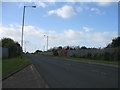
7
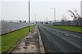
New Road (view east)
This photograph shows a view of a section of New Road which lies to the east of Chilton Lane Estate. The road links the estate (behind the photographer) with the A1046 road within the centre of industrial Teesside. The picture was taken looking in an east-south-easterly direction towards the River Tees.
Image: © Philip Barker
Taken: 24 Mar 2010
0.25 miles