IMAGES TAKEN NEAR TO
Stockton Street, MIDDLESBROUGH, TS2 1LH
Introduction
This page details the photographs taken nearby to Stockton Street, TS2 1LH by members of the Geograph project.
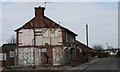
The Geograph project started in 2005 with the aim of publishing, organising and preserving representative images for every square kilometre of Great Britain, Ireland and the Isle of Man.

There are currently over 7.5m images from over14,400 individuals and you can help contribute to the project by visiting https://www.geograph.org.uk
Image Map
Images are licensed for reuse under creativecommons.org/licenses/by-sa/2.0
Notes
- Clicking on the map will re-center to the selected point.
- The higher the marker number, the further away the image location is from the centre of the postcode.
Image Listing (109 Images Found)
Images are licensed for reuse under creativecommons.org/licenses/by-sa/2.0
Image
Details
Distance
1

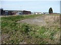
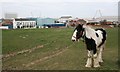
Brownfield site, east of Stockton Street, Middlesbrough
In the general area of Suffield Street. I guess there were terraced houses and workshops here, before demolition.
Image: © Christine Johnstone
Taken: 2 Apr 2015
0.02 miles
2
A former road off Suffield Street, Middlesbrough
Now part of a large brownfield site awaiting redevelopment. Bordered by Stockton, Richmond, Cleveland, Durham and Commercial Streets.
Image: © Christine Johnstone
Taken: 2 Apr 2015
0.02 miles
3
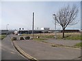
Richmond Street blocked, Middlesbrough
To stop rat-running and joy-riding across a large brownfield site.
Image: © Christine Johnstone
Taken: 2 Apr 2015
0.05 miles
4
West Street
I took this photo almost three years ago in anticipation of the derelict building standing at the corner of West Street and Stockton Street being demolished. It has finally gone.
Image: © Mick Garratt
Taken: 9 Nov 2005
0.08 miles
5
West Street, Middlesbrough
Looking south-east from Snowdon Street. The grass covers an extensive area of demolished streets.
Image: © Christine Johnstone
Taken: 2 Apr 2015
0.08 miles
6
Vine Street, St. Hilda's
The whole area of St. Hilda's is earmarked for redevelopment.
Image: © Mick Garratt
Taken: 14 Mar 2007
0.09 miles
7

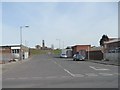
St Hildas, Middlesbrough
Originally the centre of Middlesbrough. The area around the tower was where the market was held. The whole area is set for (its second) rejuvenation. View south east along West Street.
Image: © Mick Garratt
Taken: 3 Oct 2005
0.11 miles
8

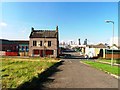
Town Hall, St. Hilda's
In 1801 Middlesbrough was a farming hamlet of just four houses occupying this slight hill overlooking the Tees estuary. In 1831 there were 154 inhabitants and ten years later 5,463. These were housed in a "new town" of cheap back to back houses built by the developers of the coal port on the Tees at the terminus of the extension of the Stockton and Darlington Railway which was opened in 1830. The new town was set out in a grid iron pattern with North, East, South and West Street radiately from a central square where the town hall and market was.
In the 1970s it was cleared and rebuilt with the "modern" housing with the town hall being saved. But these houses, seen in the background, are in turn being demolished to make way for 21st century redevelopment.
Image: © Mick Garratt
Taken: 14 Mar 2007
0.12 miles
9
St. Hilda's
Middlesbrough was born on the slight hill overlooking the Tees estuary. This area was once overcrowded with cheap back to back houses built to house the growing population of Middlesbrough. It was cleared and rebuilt with "modern" housing in the 1970s but these have in turn been demolished to make way for redevelopment.
Image: © Mick Garratt
Taken: 14 Mar 2007
0.13 miles
10
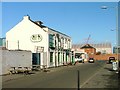
The Ship Inn
Built in 1831 and reputed to be Middlesbrough's oldest pub. Originally the entrance was from the north. This south entrance from Stockton Street was added later.
Sadly gutted by fire in April 2012 after closing as a pub see http://www.gazettelive.co.uk/news/teesside-news/2012/04/09/middlehaven-pub-in-st-hilda-s-destroyed-by-fire-84229-30724154/.
Image: © Mick Garratt
Taken: 9 Nov 2005
0.13 miles