IMAGES TAKEN NEAR TO
Sedgefield, STOCKTON-ON-TEES, TS21 2BD
Introduction
This page details the photographs taken nearby to TS21 2BD by members of the Geograph project.
The Geograph project started in 2005 with the aim of publishing, organising and preserving representative images for every square kilometre of Great Britain, Ireland and the Isle of Man.

There are currently over 7.5m images from over14,400 individuals and you can help contribute to the project by visiting https://www.geograph.org.uk
Image Map
Images are licensed for reuse under creativecommons.org/licenses/by-sa/2.0
Notes
- Clicking on the map will re-center to the selected point.
- The higher the marker number, the further away the image location is from the centre of the postcode.
Image Listing (12 Images Found)
Images are licensed for reuse under creativecommons.org/licenses/by-sa/2.0
Image
Details
Distance
2
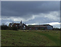
Sprucely farmhouse
This farm lies to the east of Bishop Middleham village. It is obviously old, and is shown on the first Ordnance Survey map of 1862. I would guess the farmhouse is mid 19th century, but it could be older and have been modified over the years.
Image: © Robert Graham
Taken: 18 Sep 2013
0.01 miles
3
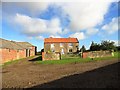
Barns at Sprucely Farm
This farm lies to the east of Bishop Middleham village.
Image: © Robert Graham
Taken: 18 Sep 2013
0.03 miles
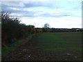
4
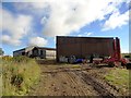
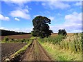
The track to Sprucely Farm
This track leads off the A177 to the farm, which lies in the fields to the east of Bishop Middleham village. The village can be seen in the distance.
Image: © Robert Graham
Taken: 18 Sep 2013
0.06 miles
5
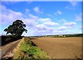
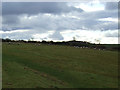
Track west of Sprucely Farm
Looking west along the track. The farm lies east of Bishop Middleham village.
Image: © Robert Graham
Taken: 18 Sep 2013
0.08 miles
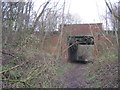
7
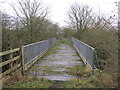
Bridge over the River Skerne for the now disused Fishburn Colliery Railway
Image: © Peter Robinson
Taken: 11 Dec 2011
0.13 miles
8
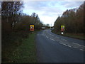
A bend in the A177
Heading north towards Spennymoor.
Image: © JThomas
Taken: 17 Nov 2012
0.17 miles
10
Bridge for the A177 road over the former Fishburn Colliery Railway track
Image: © Peter Robinson
Taken: 11 Dec 2011
0.20 miles