IMAGES TAKEN NEAR TO
Waterford Road, STOCKTON-ON-TEES, TS20 2LE
Introduction
This page details the photographs taken nearby to Waterford Road, TS20 2LE by members of the Geograph project.
The Geograph project started in 2005 with the aim of publishing, organising and preserving representative images for every square kilometre of Great Britain, Ireland and the Isle of Man.

There are currently over 7.5m images from over14,400 individuals and you can help contribute to the project by visiting https://www.geograph.org.uk
Image Map
Images are licensed for reuse under creativecommons.org/licenses/by-sa/2.0
Notes
- Clicking on the map will re-center to the selected point.
- The higher the marker number, the further away the image location is from the centre of the postcode.
Image Listing (7 Images Found)
Images are licensed for reuse under creativecommons.org/licenses/by-sa/2.0
Image
Details
Distance
1
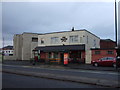
Former railway line to Billingham
This railway was built much later than most and like the chemical works that it served,does not appear on the 1920 6" map. The railway is shown as open on a 1979 1:50,000 map. It is now a cycle / footpath. A fox was sleeping here just before I arrived and took the photograph.
Image: © Richard Webb
Taken: 10 Aug 2016
0.10 miles
2
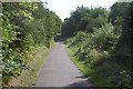
Path through the trees
A path through the trees in Great North Park
Image: © Ian Barton
Taken: 17 Aug 2008
0.11 miles
3
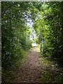
Cycle trail on dismantled railway, Stockton
Image: © JThomas
Taken: 12 Jan 2013
0.16 miles
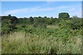
4
Wetland Area
Small area of wetland in urban Stockton. Residential estates are hidden by the line of shrubs and trees lining the Durham Coast Railway.
Image: © David Robinson
Taken: 18 Sep 2021
0.18 miles
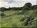
5
Wetland and scrub, Great North Park
Between the houses and railway and marked on current maps as a nature reserve.
Image: © Richard Webb
Taken: 10 Aug 2016
0.20 miles
6

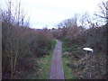
National Cycle Route 1
The wooded cutting hides the fact that the cycle path is running through urban Stockton. The former railway ran between Stockton and eastern Billingham, serving the industries on the North bank of the Tees.
Image: © David Robinson
Taken: 18 Sep 2021
0.23 miles