IMAGES TAKEN NEAR TO
Alpha Grove, STOCKTON-ON-TEES, TS20 2HA
Introduction
This page details the photographs taken nearby to Alpha Grove, TS20 2HA by members of the Geograph project.
The Geograph project started in 2005 with the aim of publishing, organising and preserving representative images for every square kilometre of Great Britain, Ireland and the Isle of Man.

There are currently over 7.5m images from over14,400 individuals and you can help contribute to the project by visiting https://www.geograph.org.uk
Image Map (Loading...)


Getting Data...Please wait
Leaflet Map data © OpenStreetMap
Images are licensed for reuse under creativecommons.org/licenses/by-sa/2.0
Notes
- Clicking on the map will re-center to the selected point.
- The higher the marker number, the further away the image location is from the centre of the postcode.
Image Listing (9 Images Found)
Images are licensed for reuse under creativecommons.org/licenses/by-sa/2.0
Image
Details
Distance
1
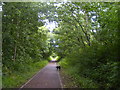
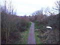
Cycle path through the trees
This is an old railway line converted to a cycle path (also suitable for dog walking).
Image: © Ian Barton
Taken: 10 Aug 2008
0.13 miles
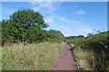
2
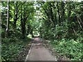
National Cycle Route 1
The wooded cutting hides the fact that the cycle path is running through urban Stockton. The former railway ran between Stockton and eastern Billingham, serving the industries on the North bank of the Tees.
Image: © David Robinson
Taken: 18 Sep 2021
0.19 miles
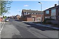
4
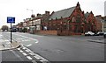
Norton Road Methodist Church
At the junction with Victoria Avenue. A former school building now used as the Norton Road Methodist Church.
Image: © Mick Garratt
Taken: 8 Jan 2008
0.19 miles
8
Cycle trail on dismantled railway, Stockton
Image: © JThomas
Taken: 12 Jan 2013
0.24 miles
9
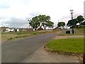
Railway trackbed, Black Roads
There was once a railway here which served ICI at Billingham. It was probably built in the 1920s and does not feature on the 1920 6" map. The railway is shown as open on a 1979 1:50,000 map. The land here is shown in the 1950s as farmland between Norton and Billingham although there is evidence of industrial use on the ground. It is now home to formal and informal recreational space, woodland and a prison.
Image: © Richard Webb
Taken: 10 Aug 2016
0.25 miles