IMAGES TAKEN NEAR TO
Spruce Road, STOCKTON-ON-TEES, TS19 0ND
Introduction
This page details the photographs taken nearby to Spruce Road, TS19 0ND by members of the Geograph project.
The Geograph project started in 2005 with the aim of publishing, organising and preserving representative images for every square kilometre of Great Britain, Ireland and the Isle of Man.

There are currently over 7.5m images from over14,400 individuals and you can help contribute to the project by visiting https://www.geograph.org.uk
Image Map (Loading...)


Getting Data...Please wait
Leaflet Map data © OpenStreetMap
Images are licensed for reuse under creativecommons.org/licenses/by-sa/2.0
Notes
- Clicking on the map will re-center to the selected point.
- The higher the marker number, the further away the image location is from the centre of the postcode.
Image Listing (8 Images Found)
Images are licensed for reuse under creativecommons.org/licenses/by-sa/2.0
Image
Details
Distance
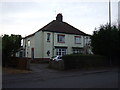
2
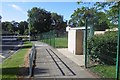
Ragpath Lane
The area east of Durham Road was urban on the 1953 1:25,000 map but has since been redeveloped with a different road pattern, including Ragpath Lane which is not on that map.
Image: © Richard Webb
Taken: 10 Aug 2016
0.14 miles
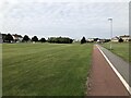
3
Ragpath Lane
Passing St Gregory's Catholic Academy. (A primary school)
Image: © Richard Webb
Taken: 10 Aug 2016
0.15 miles
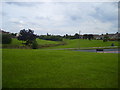
4
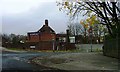
Darlington Lane/Ragpath Lane Junction, Ragworth
Image: © Mick Garratt
Taken: 22 Nov 2006
0.20 miles
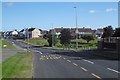
5
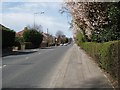
A177 In Springtime
This part of the A177 road was built about 1830 (proposed route on a 1828 map). It is a straight road of 3.5 miles from Stockton to Thorpe Thewles, which would have improved access to Sedgefield, and to Lord Londondery's estate at Wynyard.
Image: © Peter Edwards
Taken: 11 Apr 2010
0.23 miles
6
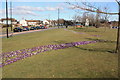
Crocus display in Ragworth
This photograph shows a view of some of the purple and white crocuses growing on the grass verge of the A1027 road near Ragworth. The picture was taken looking in a north-north-easterly direction towards Norton.
Image: © Philip Barker
Taken: 13 Mar 2010
0.24 miles