IMAGES TAKEN NEAR TO
Bromley Road, STOCKTON-ON-TEES, TS18 4HE
Introduction
This page details the photographs taken nearby to Bromley Road, TS18 4HE by members of the Geograph project.
The Geograph project started in 2005 with the aim of publishing, organising and preserving representative images for every square kilometre of Great Britain, Ireland and the Isle of Man.

There are currently over 7.5m images from over14,400 individuals and you can help contribute to the project by visiting https://www.geograph.org.uk
Image Map
Images are licensed for reuse under creativecommons.org/licenses/by-sa/2.0
Notes
- Clicking on the map will re-center to the selected point.
- The higher the marker number, the further away the image location is from the centre of the postcode.
Image Listing (11 Images Found)
Images are licensed for reuse under creativecommons.org/licenses/by-sa/2.0
Image
Details
Distance

2
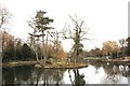
Island in Ropner Park
This photograph shows a view of one of the three islands that are to be found in the lake within the north-western area of Ropner Park. This picture was taken looking in a north-north-easterly direction towards Oxbridge cemetery.
Image: © Philip Barker
Taken: 19 Feb 2010
0.13 miles

4
Dismantled Railway
This photograph shows a view of the (now dismantled) railway that used to run between Stockton and Thorpe Thewles. The route now forms part of the National Cycle Network.The picture was taken looking in a north-westerly direction towards Thorpe Thewles.
Image: © Philip Barker
Taken: 19 Feb 2010
0.19 miles
5
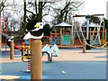
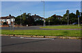
Playpark, Ropner Park
Newly constructed and looks like it's unopened yet.
Image: © Mick Garratt
Taken: 25 Jan 2006
0.21 miles
6
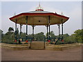
The bandstand at Ropner Park
This park is a wonderful example of how a derelict and forlorn place used by drug addicts and unsafe to enter has been reclaimed by local people for their leisure. Bands play regularly in the new bandstand.
Image: © Carol Rose
Taken: 16 Sep 2006
0.22 miles
7
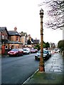
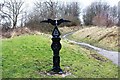
Sewer Ventilation Pipe, Richmond Road, Stockton-on-Tees
Probably Victorian, also the purpose is a guess.
Image: © Mick Garratt
Taken: 25 Jan 2006
0.23 miles
10
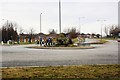
Roundabout in Oxbridge
This photograph shows a view of the roundabout at the intersection of Oxbridge Lane and Hartburn Avenue in Stockton-on-Tees. The picture was taken looking in a north-westerly direction towards the Fairfield area of Stockton.
Image: © Philip Barker
Taken: 19 Feb 2010
0.24 miles