IMAGES TAKEN NEAR TO
Brusselton Court, STOCKTON-ON-TEES, TS18 3AN
Introduction
This page details the photographs taken nearby to Brusselton Court, TS18 3AN by members of the Geograph project.
The Geograph project started in 2005 with the aim of publishing, organising and preserving representative images for every square kilometre of Great Britain, Ireland and the Isle of Man.

There are currently over 7.5m images from over14,400 individuals and you can help contribute to the project by visiting https://www.geograph.org.uk
Image Map
Images are licensed for reuse under creativecommons.org/licenses/by-sa/2.0
Notes
- Clicking on the map will re-center to the selected point.
- The higher the marker number, the further away the image location is from the centre of the postcode.
Image Listing (22 Images Found)
Images are licensed for reuse under creativecommons.org/licenses/by-sa/2.0
Image
Details
Distance
1
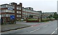
Ashmore House
Taken from just outside the grid square Ashmore House was built as the headquarters of Davy Ashmore Ltd., which came into existence after Power Gas Corporation (established in 1901) merged with Davy United to become Davy Ashmore Ltd. In 1973 it later became known as Davy International Ltd. and in 1980 Davy McKee.
The eighties and nineties saw the amalgamation, mergers and take overs of several well known engineering businesses. Head Wrightson, Redpath Dorman Long and Davy Mckee all lost their identities under the umbrella of commercially successful conglomerate John Brown and Company. John Brown and Company was taken over by Trafalgar House which itself was brought by the Norwegian group of companies Kværner.
In 2004 Aker Maritime and Kværner merged to form Aker Kværner, the current occupiers of the building.
Image: © Mick Garratt
Taken: 10 Oct 2006
0.15 miles
2
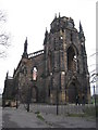
Holy Trinity Church
Holy Trinity Church, Stockton on Tees - built 1834-8, designed by John and Benjamin Green.
Image: © Jonathan Thacker
Taken: 19 Nov 2009
0.20 miles
3
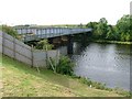
Disused Railway Bridge Over the River Tees
Viewed from the south bank, although because the meandering of the river actually looking south west. The new railway bridge is immediately behind whilst the A66 road bridge is behind that.
Image: © Mick Garratt
Taken: 28 Sep 2005
0.21 miles
4
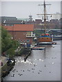
Castlegate Quay : Stockton-on-Tees
HM Bark Endeavour, moored at Castlegate Quay, This is a full size replica of the ship Captain Cook used in his first voyage of discovery to Australia. (launched in 1993)
Image: © Hugh Mortimer
Taken: 15 Oct 2006
0.21 miles
5
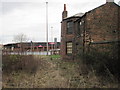
Stockton (S&DR) Bridge Road railway station (site), County Durham
Converted in 1826 into a weigh house for the Stockton and Darlington Railway, this building may have also sold passenger tickets. Steam-hauled passenger trains ran between here and Darlington from 1833 to 1848. It continued as a goods station long after S&DR passengers had transferred to South Stockton railway station (see Image), which was only a few minutes walk away across the river Tees, and therefore located in Yorkshire.
This site is also historic in that the first tracks of the Stockton and Darlington Railway were laid here in 1822.
View north east over a former level crossing. As built we would be looking towards the coal staithes on the River Tees
Image: © Nigel Thompson
Taken: 1 Jan 2015
0.22 miles
6
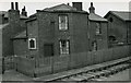
Stockton, original S&D Railway station of 1825
Terminus of the original Stockton & Darlington Railway of 1825; located at St John's Crossing, near Dock; closed 1892, although trains ceased to terminate there in 1863. This is a Grade II* Listed Building. Please see Image] for a close-up of the plaque on the wall. From StreetView this plaque had been removed by October 2014.
Image: © Walter Dendy, deceased
Taken: 18 Apr 1954
0.22 miles
7
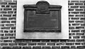
Commemorative plaque on former booking-hall of S&D Railway, Stockton
'Here in 1825 the Stockton and Darlington Railway Company booked the first passenger, thus marking an epoch in the history of mankind'.
The plaque can be seen on the side wall of Image From StreetView it had been removed from the building by October 2014.
Image: © Walter Dendy, deceased
Taken: 18 Apr 1954
0.22 miles
8
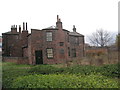
The world's oldest railway ticket office
The world's first passenger ticket was sold here in 1825.
Image: © Jonathan Thacker
Taken: 19 Nov 2009
0.22 miles
9
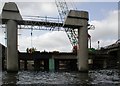
Surtees Bridge
Construction of the new Surtees Bridge over the Tees is continuing. The new bridge carrying two lanes is opened and here the old bridge has been cut away and removed. It looks as though the old piers will be reused.
Why "Surtees"? There are two theories. Firstly it is named after the Surtees family, lords of the manor of Dinsdale in medieval times. Alternatively it's a corruption of the french "sur Tees" meaning on the Tees.
Image: © Mick Garratt
Taken: 1 Apr 2007
0.23 miles
10
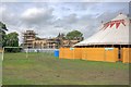
Church of the Holy Trinity
A Grade II listed building currently undergoing restoration. New stonework on the parapet can be seen. The big top was for the Stockton International Festival held the previous weekend.
Image: © Mick Garratt
Taken: 6 Aug 2008
0.23 miles