IMAGES TAKEN NEAR TO
TS17 7AB
Introduction
This page details the photographs taken nearby to TS17 7AB by members of the Geograph project.
The Geograph project started in 2005 with the aim of publishing, organising and preserving representative images for every square kilometre of Great Britain, Ireland and the Isle of Man.

There are currently over 7.5m images from over14,400 individuals and you can help contribute to the project by visiting https://www.geograph.org.uk
Image Map
Images are licensed for reuse under creativecommons.org/licenses/by-sa/2.0
Notes
- Clicking on the map will re-center to the selected point.
- The higher the marker number, the further away the image location is from the centre of the postcode.
Image Listing (42 Images Found)
Images are licensed for reuse under creativecommons.org/licenses/by-sa/2.0
Image
Details
Distance
1
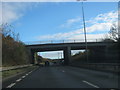
Bridge for Westbury Street over the A66
Image: © Peter Robinson
Taken: 11 Nov 2012
0.04 miles
2
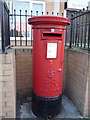
Elizabeth II Postbox on Mandale Road, Thornaby-on-Tees
Postbox No. TS17 318.
See Image] for context.
Image: © JThomas
Taken: 7 Jul 2018
0.08 miles
3
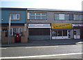
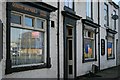
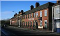
Shops on Mandale Road, Thornaby-on-Tees
Showing position of Postbox No. TS17 318.
See Image] for postbox.
Image: © JThomas
Taken: 7 Jul 2018
0.08 miles
4
The Market Tavern, New Street, Thornaby-on-Tees
Image: © Mick Garratt
Taken: 23 Jan 2007
0.11 miles
5
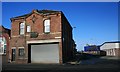
Former Thornaby Fire Station
Built in the late 1800s this building was used by the Thornaby Fire Brigade through nationalisation in 1941 until 1974 when a new fire station was built on Master Road in the new town.
Image: © Mick Garratt
Taken: 23 Jan 2007
0.12 miles
6
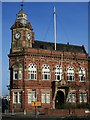
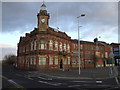
Thornaby Town Hall
Built in 1892 the Town Hall was a source of pride for the young town. A plaque reads: "By The Generosity Of Alderman William Anderson, First Mayor of Thornaby-on-Tees The Clock and Chimes in this Tower were given for the Benefit of the People." The architect was James Garry of West Hartlepool. Pevsner describes the building as "a totally undistinguished design on a visually most unsuitable site". Not to his taste then.
Today the Thornaby Town Council stills meets here although most of the original administrative functions of the Municipal Borough of Thornaby-on-Tees have been absorbed into the present Borough Council of Stockton-on-Tees. The building itself is Grade II listed.
Image: © Mick Garratt
Taken: 23 Jan 2007
0.13 miles
7
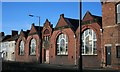
Disused Library
Situated in what is known locally as the Thornaby Triangle, in effect an island surrounded by a busy one way system this once proud building now stands neglected. It was presented to the town in 1892 by T Wrightson Esq. of Head Wrightsons, the iron and steel company which occupied the substantial area of land on the banks of the Tees known as Thornaby Carrs. Head Wrightsons was obviously a major employer in the town.
Image: © Mick Garratt
Taken: 23 Jan 2007
0.14 miles
9
Former Thornaby Police Station
On George Street in the Mandale Triangle. Now occupied by various businesses.
Image: © Mick Garratt
Taken: 23 Jan 2007
0.16 miles