IMAGES TAKEN NEAR TO
Thornaby Road, STOCKTON-ON-TEES, TS17 6HE
Introduction
This page details the photographs taken nearby to Thornaby Road, TS17 6HE by members of the Geograph project.
The Geograph project started in 2005 with the aim of publishing, organising and preserving representative images for every square kilometre of Great Britain, Ireland and the Isle of Man.

There are currently over 7.5m images from over14,400 individuals and you can help contribute to the project by visiting https://www.geograph.org.uk
Image Map
Images are licensed for reuse under creativecommons.org/licenses/by-sa/2.0
Notes
- Clicking on the map will re-center to the selected point.
- The higher the marker number, the further away the image location is from the centre of the postcode.
Image Listing (20 Images Found)
Images are licensed for reuse under creativecommons.org/licenses/by-sa/2.0
Image
Details
Distance
1
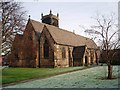
Church of St Paul the Apostle, Thornaby
This photograph of the church in North Thornaby was taken from just inside the church grounds near the junction of Cambridge Road with Thornaby Road (A1045). Notice the two different 'colours' of the grass: that on the right has an early-morning frost while that on the left has thawed out.
Image: © Philip Barker
Taken: 19 Jan 2010
0.08 miles
3
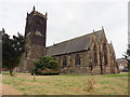
Thornaby on Tees, North Yorkshire, St Paul
Image: © Dave Kelly
Taken: 13 Jul 2018
0.08 miles
4
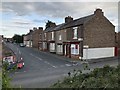
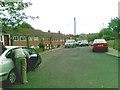
Gilmour Street, Thornaby
Terraced houses on Gilmour Street.
Image: © David Robinson
Taken: 12 Jul 2019
0.12 miles

8
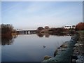
River Tees at Thornaby
This photograph shows a view of the River Tees near North Thornaby. The picture was taken from the east bank looking in a northerly direction towards the centre of Stockton-on-Tees. The bridge seen in the distance is the new road bridge that carries the A66 road over the river. Just beyond the new bridge, parts of the railway bridge can just be seen.
Image: © Philip Barker
Taken: 19 Jan 2010
0.17 miles
10
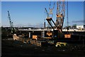
Surtees Bridge
Carrying the A66 over the River Tees, the bridge is currently being widened at a cost of £14.3m. Apart having only two lanes (in each direction) the existing bridge could not meet the specification for the latest 40te lorries. The work is expected to be complete in Autumn 2007. The 344t sections of the bridge was lifted into place by a 1200t Gottwald AK680 crane, seen here on the right.
Why "Surtees"? There are two theories. Firstly it is named after the Surtees family, lords of the manor of Dinsdale in medieval times. Alternatively it's a corruption of the french "sur Tees" meaning on the Tees.
Image: © Mick Garratt
Taken: 30 Jan 2007
0.20 miles