IMAGES TAKEN NEAR TO
Kirkbride Way, STOCKTON-ON-TEES, TS17 5NN
Introduction
This page details the photographs taken nearby to Kirkbride Way, TS17 5NN by members of the Geograph project.
The Geograph project started in 2005 with the aim of publishing, organising and preserving representative images for every square kilometre of Great Britain, Ireland and the Isle of Man.

There are currently over 7.5m images from over14,400 individuals and you can help contribute to the project by visiting https://www.geograph.org.uk
Image Map
Images are licensed for reuse under creativecommons.org/licenses/by-sa/2.0
Notes
- Clicking on the map will re-center to the selected point.
- The higher the marker number, the further away the image location is from the centre of the postcode.
Image Listing (4 Images Found)
Images are licensed for reuse under creativecommons.org/licenses/by-sa/2.0
Image
Details
Distance
1
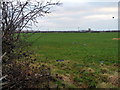
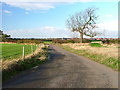
Farmland adjacent to Barwick Farm Cottage
Taken from the path at the far western edge of The Rings
Image: © Graham Scarborough
Taken: 29 Dec 2008
0.09 miles
3
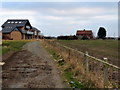
Path at the westernmost edge of The Rings
The red brick building is Barwick Farm Cottage and the modern buildings are premium builds on the westernmost edge of The Rings, Ingleby Barwick.
Image: © Graham Scarborough
Taken: 29 Dec 2008
0.21 miles
4
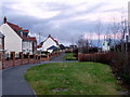
Site of an old footpath, incorporated into the street layout
Adjacent to The Rings, Ingleby Barwick
Image: © Graham Scarborough
Taken: 28 Dec 2008
0.24 miles