IMAGES TAKEN NEAR TO
De Brus Close, YARM, TS15 9ZE
Introduction
This page details the photographs taken nearby to De Brus Close, TS15 9ZE by members of the Geograph project.
The Geograph project started in 2005 with the aim of publishing, organising and preserving representative images for every square kilometre of Great Britain, Ireland and the Isle of Man.

There are currently over 7.5m images from over14,400 individuals and you can help contribute to the project by visiting https://www.geograph.org.uk
Image Map
Images are licensed for reuse under creativecommons.org/licenses/by-sa/2.0
Notes
- Clicking on the map will re-center to the selected point.
- The higher the marker number, the further away the image location is from the centre of the postcode.
Image Listing (19 Images Found)
Images are licensed for reuse under creativecommons.org/licenses/by-sa/2.0
Image
Details
Distance
3
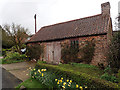
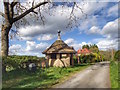
The Old Smithy
Still containing the original forge. This building was in use in 1766 when Richard Mudd was the blacksmith. The anvil is in Bowes Museum.
Image: © Mick Garratt
Taken: 14 Apr 2016
0.12 miles
5
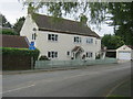
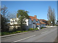
Corner Cottage in Village Road, Low Worsall
Image: © Peter Robinson
Taken: 16 Sep 2012
0.12 miles
6
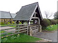
Lych gate, All Saints Church
Many churches have a lych gate built over the main entrance to the enclosed area round the church. The name, also spelt lich or lytch, is from the Anglo Saxon 'lich' meaning corpse. The gate marks the division between consecrated and unconsecrated ground, where the bearers sheltered with the coffin, waiting for the clergyman to lead the procession before the burial. The original lych gates had seats, a lych cross and a lych stone - a slab on which the coffin rested.
Image: © Maigheach-gheal
Taken: 4 Apr 2011
0.13 miles
7
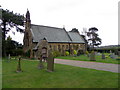
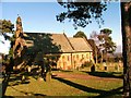
All Saints Church, Worsall
The church dates from 1894 and is by Armfield and Moscrop. It is built in the Early English style.
Image: © Maigheach-gheal
Taken: 4 Apr 2011
0.13 miles
8
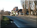
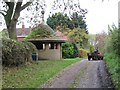
Strange place for a Bus Shelter
This peculiar shelter is beside Stobarts Lane, a byway, in Low Worsall, I have no idea why it is there.
Image: © Paul Buckingham
Taken: 18 May 2011
0.13 miles
9
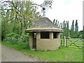
Shelter, Low Worsall
A Grade II Listed building, see http://www.britishlistedbuildings.co.uk/en-331914-shelter-low-worsall-north-yorkshire#.VUDeQc55ZS8
Probably 1920s. Ashlar with graduated stone slate roof, tall lead ball finial. Small
circular building with entrance flanked by an open panel at either side, the door
jambs and panel divisions circular on plan. Radial stone floor paving, eight radial
joists support an octagonal king post against which are closely abutted the rafters
which show at the eaves, ashlared to give a sweep to the roof.
Inscription on rear wall: In memory of Edward and Mary Temple.
Image: © Mick Garratt
Taken: 28 Apr 2015
0.14 miles
10
An unusual memorial
A beautifully built, but curious memorial shelter at the side of a back lane in Low Worsall. The building dates from the 1920's and was built in memory of Edward and Mary Temple. It is grade II listed. But why build it here, tucked away in a back lane, and not on the village green?
Image: © Gordon Hatton
Taken: 4 Nov 2023
0.14 miles