IMAGES TAKEN NEAR TO
Bankside, YARM, TS15 9RH
Introduction
This page details the photographs taken nearby to Bankside, TS15 9RH by members of the Geograph project.
The Geograph project started in 2005 with the aim of publishing, organising and preserving representative images for every square kilometre of Great Britain, Ireland and the Isle of Man.

There are currently over 7.5m images from over14,400 individuals and you can help contribute to the project by visiting https://www.geograph.org.uk
Image Map
Images are licensed for reuse under creativecommons.org/licenses/by-sa/2.0
Notes
- Clicking on the map will re-center to the selected point.
- The higher the marker number, the further away the image location is from the centre of the postcode.
Image Listing (7 Images Found)
Images are licensed for reuse under creativecommons.org/licenses/by-sa/2.0
Image
Details
Distance
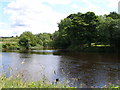
2
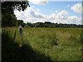
The treelined river bank and the footpath begin to swing to the right
Image: © Carol Rose
Taken: 7 Jul 2007
0.14 miles
3
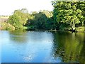
The Confluence of the River Leven and the River Tees
Image: © Paul Buckingham
Taken: 25 Sep 2011
0.15 miles
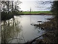
4
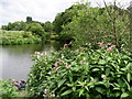
Confluence of the Tees and Leven
The River Leven empties its waters into the River Tees at this point near Roundhill, after an erratic journey that commences in the Cleveland Hills.
Image: © Chris Heaton
Taken: 7 Jul 2010
0.15 miles
5
The confluence of the River Tees and the River Leven
Image: © Carol Rose
Taken: 7 Jul 2007
0.15 miles
6
The confluence of the Leven and the Tees
The confluence of the Leven and the Tees, looking from the Leven towards the Tees
Image: © Graham Scarborough
Taken: 2 Feb 2008
0.15 miles
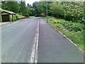
7
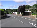
Valley Drive : Yarm
Estate to the south-east of Yarm and the River Tees. Built on the site of Clock House Woods.
Image: © Hugh Mortimer
Taken: 2 Sep 2006
0.18 miles