IMAGES TAKEN NEAR TO
Woodlands Drive, YARM, TS15 9NU
Introduction
This page details the photographs taken nearby to Woodlands Drive, TS15 9NU by members of the Geograph project.
The Geograph project started in 2005 with the aim of publishing, organising and preserving representative images for every square kilometre of Great Britain, Ireland and the Isle of Man.

There are currently over 7.5m images from over14,400 individuals and you can help contribute to the project by visiting https://www.geograph.org.uk
Image Map (Loading...)


Getting Data...Please wait
Leaflet Map data © OpenStreetMap
Images are licensed for reuse under creativecommons.org/licenses/by-sa/2.0
Notes
- Clicking on the map will re-center to the selected point.
- The higher the marker number, the further away the image location is from the centre of the postcode.
Image Listing (2 Images Found)
Images are licensed for reuse under creativecommons.org/licenses/by-sa/2.0
Image
Details
Distance
1
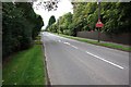
Leven Road
This photograph shows a view of a section of Leven Road which runs parallel to the southern edge of the grid-square. The picture was taken near Rose Hill looking in a westerly direction towards the road junction on the A67 road close to The Rookery.
Image: © Philip Barker
Taken: 22 Sep 2010
0.11 miles
2
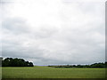
View across a Loop in the River Tees
This looks across land inside a southern meander created by the River Tees. The trees and housing on the skyline are part of Roundhill Village, which is the other side of the loop.
Image: © Chris Heaton
Taken: 7 Jul 2010
0.24 miles