IMAGES TAKEN NEAR TO
Turton Road, YARM, TS15 9DN
Introduction
This page details the photographs taken nearby to Turton Road, TS15 9DN by members of the Geograph project.
The Geograph project started in 2005 with the aim of publishing, organising and preserving representative images for every square kilometre of Great Britain, Ireland and the Isle of Man.

There are currently over 7.5m images from over14,400 individuals and you can help contribute to the project by visiting https://www.geograph.org.uk
Image Map
Images are licensed for reuse under creativecommons.org/licenses/by-sa/2.0
Notes
- Clicking on the map will re-center to the selected point.
- The higher the marker number, the further away the image location is from the centre of the postcode.
Image Listing (8 Images Found)
Images are licensed for reuse under creativecommons.org/licenses/by-sa/2.0
Image
Details
Distance
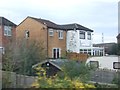
2
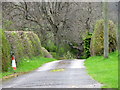
Driveway, Yarm
The driveway also acts as a footpath. The footpath takes walkers towards Lowlands Farm.
Image: © Maigheach-gheal
Taken: 4 Apr 2011
0.20 miles
3
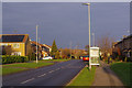
Davenport Road, Yarm
Davenport Road is part of the Willey Flatts Estate to the south of Yarm town centre. The bus stop is at Mayes Walk and is the nearest to Yarm station.
Image: © Stephen McKay
Taken: 12 Dec 2018
0.20 miles
5
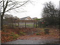
Access to the railway, The Meadowings, Yarm
Image: © Jonathan Thacker
Taken: 26 Nov 2012
0.21 miles
6
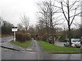
The Meadowings, Yarm
The railway from Thornaby to Northallerton runs behind the hedge on the left.
Image: © Jonathan Thacker
Taken: 26 Nov 2012
0.22 miles
7
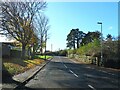
Worsall Road, Yarm
The B1265 leads south westwards out of town towards the village of Low Worsall.
Image: © Gordon Hatton
Taken: 10 Nov 2023
0.22 miles