IMAGES TAKEN NEAR TO
Low Church Wynd, YARM, TS15 9BA
Introduction
This page details the photographs taken nearby to Low Church Wynd, TS15 9BA by members of the Geograph project.
The Geograph project started in 2005 with the aim of publishing, organising and preserving representative images for every square kilometre of Great Britain, Ireland and the Isle of Man.

There are currently over 7.5m images from over14,400 individuals and you can help contribute to the project by visiting https://www.geograph.org.uk
Image Map
Images are licensed for reuse under creativecommons.org/licenses/by-sa/2.0
Notes
- Clicking on the map will re-center to the selected point.
- The higher the marker number, the further away the image location is from the centre of the postcode.
Image Listing (167 Images Found)
Images are licensed for reuse under creativecommons.org/licenses/by-sa/2.0
Image
Details
Distance
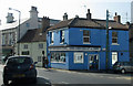
1
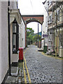
Low Church Wynd
A narrow, cobbled street passing under the Yarm Viaduct which carries the Middlesbrough to Northallerton Railway.
Image: © Pauline E
Taken: 16 Jun 2011
0.01 miles
3
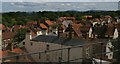
Yarm: rooftops from the railway viaduct
Image: © Christopher Hilton
Taken: 11 Jul 2015
0.02 miles
4
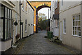
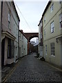
Low Church Wynd, Yarm
There are several 'wynds' leading off the High Street in Yarm. Originally the buildings here were seen as inferior dwellings to those on the High Street itself, but in more recent times they have become sought after. This is the most northerly wynd, leading through an arch of Yarm viaduct.
Image: © Stephen McKay
Taken: 10 Dec 2018
0.02 miles
5
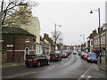
Shops in Yarm
Yarm is a very busy small town with a prosperous air.
Image: © Colin Grice
Taken: 28 Apr 2011
0.03 miles
6

International relations
Twinned with Vernouillet since 1985 http://en.wikipedia.org/wiki/Vernouillet,_Yvelines
http://en.wikipedia.org/wiki/Schwalbach_am_Taunus
Image: © Pauline E
Taken: 16 Jun 2011
0.03 miles
7
Traffic in Yarm
A queue of traffic passing through Yarm High Street on a Sunday afternoon. The high street is on the route of the A67 road.
Image: © Malc McDonald
Taken: 3 Mar 2019
0.03 miles
8
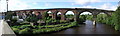
Yarm : Railway Viaduct : 1849
The north end of Yarm Viaduct, taken from Yarm Bridge.
Image: © Hugh Mortimer
Taken: 3 Sep 2006
0.03 miles
9
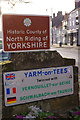
Entering Yarm
Arriving in Yarm High Street over Yarm Bridge, motorists see these two signs, one using the full name Yarm-on-Tees, which is not used by the Ordnance Survey or anywhere else much, and the other announcing that this is the 'Historic County of North Riding of Yorkshire' which is technically correct but potentially confusing because no modern administrative boundary has been crossed. Yarm was incorporated into the newly created county of Cleveland in 1974 under the Local Government Act 1972; when Cleveland was abolished just 22 years later the town became part of Stockton-On-Tees unitary authority. However, for ceremonial purposes the parts of Cleveland south of the Tees were placed into North Yorkshire (which covers a similar, but not identical, area to the old North Riding). To add to the confusion, the Cleveland name lives on in organisations such as Cleveland Police. One thing can be said, though - the people of Yarm consider theirs to be a Yorkshire town - and always have done.
Image: © Stephen McKay
Taken: 10 Dec 2018
0.04 miles
10
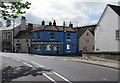
Corner of Bridge Street and High Street, Yarm
A computer shop currently occupies the corner plot.
Image: © Pauline E
Taken: 27 Mar 2011
0.04 miles