IMAGES TAKEN NEAR TO
Upper Garth Gardens, GUISBOROUGH, TS14 6HA
Introduction
This page details the photographs taken nearby to Upper Garth Gardens, TS14 6HA by members of the Geograph project.
The Geograph project started in 2005 with the aim of publishing, organising and preserving representative images for every square kilometre of Great Britain, Ireland and the Isle of Man.

There are currently over 7.5m images from over14,400 individuals and you can help contribute to the project by visiting https://www.geograph.org.uk
Image Map
Images are licensed for reuse under creativecommons.org/licenses/by-sa/2.0
Notes
- Clicking on the map will re-center to the selected point.
- The higher the marker number, the further away the image location is from the centre of the postcode.
Image Listing (82 Images Found)
Images are licensed for reuse under creativecommons.org/licenses/by-sa/2.0
Image
Details
Distance
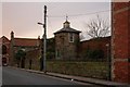
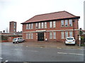
1
Guisborough Register Office
Soon to move a building out of town as this one is too costly to maintain.
Image: © Mick Garratt
Taken: 7 Dec 2007
0.06 miles
3
Guisborough Register Office
Soon to move a building out of town as this one is too costly to maintain.
Image: © Mick Garratt
Taken: 7 Dec 2007
0.06 miles
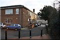
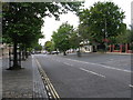
4
Guisborough main street
Parking on Westgate in Guisborough.
Image: © Helen Wilkinson
Taken: 28 Jun 2009
0.08 miles
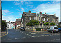
5
Distinctive Building on Westgate Road
See the Grid Square Discussion http://www.geograph.org.uk/discuss/index.php?&action=vthread&forum=5&topic=8639
Image: © Mick Garratt
Taken: 22 Jan 2008
0.10 miles
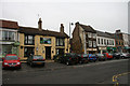
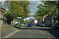
6
Westgate, Guisborough
Westgate is the attractive main road through Guisborough. The western end is residential and the eastern end is the main shopping area of Guisborough. The parking areas are cobbled. This was formerly the busy A171 prior to the A171 bypassing Guisborough.
Image: © G Laird
Taken: 6 Sep 2017
0.10 miles
7
Westgate, Guisborough
The main street.
Image: © Robin Webster
Taken: 7 Oct 2011
0.10 miles
8
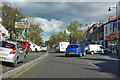
Westgate, Guisborough
The main street.
Image: © Robin Webster
Taken: 7 Oct 2011
0.10 miles
9
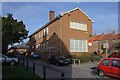
Guisborough's Drill Hall, now housing
On the north side of Park Lane, immediately east of the Fire Station.
Image: © Christine Johnstone
Taken: 3 Apr 2015
0.11 miles
10
Sunnyfield House, Westgate, Guisborough
This 18C house is now a museum.
Image: © Humphrey Bolton
Taken: 2 Aug 2020
0.12 miles