IMAGES TAKEN NEAR TO
Westgate, GUISBOROUGH, TS14 6AF
Introduction
This page details the photographs taken nearby to Westgate, TS14 6AF by members of the Geograph project.
The Geograph project started in 2005 with the aim of publishing, organising and preserving representative images for every square kilometre of Great Britain, Ireland and the Isle of Man.

There are currently over 7.5m images from over14,400 individuals and you can help contribute to the project by visiting https://www.geograph.org.uk
Image Map (Loading...)


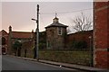
Getting Data...Please wait
Leaflet Map data © OpenStreetMap
Images are licensed for reuse under creativecommons.org/licenses/by-sa/2.0
Notes
- Clicking on the map will re-center to the selected point.
- The higher the marker number, the further away the image location is from the centre of the postcode.
Image Listing (111 Images Found)
Images are licensed for reuse under creativecommons.org/licenses/by-sa/2.0
Image
Details
Distance
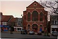
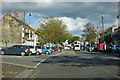
2
Westgate, Guisborough
The main street.
Image: © Robin Webster
Taken: 7 Oct 2011
0.02 miles
4
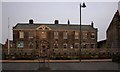
Sunnyfield House
An eighteenth century Grade II listed house built for John Harrison, an attorney and agent to the Chaloner estate of Lord Gisborough. From the mid fifties to the early seventies it was used as a training centre for the Jackson Burton Group who then had a substantial factory on the west end of town. In 1972 the Guisborough Urban District Council took the house over, followed by various evolutions of the local authority. Since 1981 Guisborough Town Council bought the House using it as a Community Centre.
Image: © Mick Garratt
Taken: 22 Jan 2008
0.03 miles
5
Westgate, Guisborough
The main street.
Image: © Robin Webster
Taken: 7 Oct 2011
0.03 miles
6
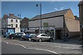
Former Post Office
Taken for comparison with Geoff Royle's photo of over 50 years ago, see Image The post office has now closed and is incorporated into a chocolate/ greeting card shop a few doors down West Gate.
Three shop units have been created out of the building. On the corner is an estate agency, then a bakery and a clothing outlet which looks like it's changing again. On the far corner of Chaloner Street Maynards occupy the former premises of L Thirkell, which was also a newsagent.
Image: © Mick Garratt
Taken: 22 Apr 2009
0.03 miles
7
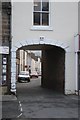
Alley Leading to Mill Street
The keystone in the arch is inscribed "W.W. 1864". I speculate that this refers to William Weatherill, Clerk to the Board of Health on its creation in 1865. The Board was set up following outbreaks of smallpox in 1859 and again in 1863.
Image: © Mick Garratt
Taken: 7 Dec 2007
0.04 miles
8
Sunnyfield House, Westgate, Guisborough
This 18C house is now a museum.
Image: © Humphrey Bolton
Taken: 2 Aug 2020
0.04 miles
9
Distinctive Building on Westgate Road
See the Grid Square Discussion http://www.geograph.org.uk/discuss/index.php?&action=vthread&forum=5&topic=8639
Image: © Mick Garratt
Taken: 22 Jan 2008
0.04 miles
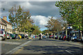
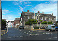
10
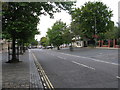
Westgate, Guisborough
Westgate is the attractive main road through Guisborough. The western end is residential and the eastern end is the main shopping area of Guisborough. The parking areas are cobbled. This was formerly the busy A171 prior to the A171 bypassing Guisborough.
Image: © G Laird
Taken: 6 Sep 2017
0.05 miles