IMAGES TAKEN NEAR TO
Staithes, SALTBURN-BY-THE-SEA, TS13 5DU
Introduction
This page details the photographs taken nearby to TS13 5DU by members of the Geograph project.
The Geograph project started in 2005 with the aim of publishing, organising and preserving representative images for every square kilometre of Great Britain, Ireland and the Isle of Man.

There are currently over 7.5m images from over14,400 individuals and you can help contribute to the project by visiting https://www.geograph.org.uk
Image Map (Loading...)


Getting Data...Please wait
Leaflet Map data © OpenStreetMap
Images are licensed for reuse under creativecommons.org/licenses/by-sa/2.0
Notes
- Clicking on the map will re-center to the selected point.
- The higher the marker number, the further away the image location is from the centre of the postcode.
Image Listing (13 Images Found)
Images are licensed for reuse under creativecommons.org/licenses/by-sa/2.0
Image
Details
Distance
1
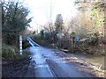
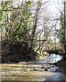
Roxby Beck ford
Just 50m or so from where two becks meet, but at this point there's not enough flow in Roxby Beck to cover the road at the ford.
Image: © Gordon Hatton
Taken: 9 Feb 2019
0.03 miles
2
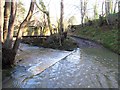
Easington Beck ford
Unlike nearby Roxby Beck which I photographed on the same visit, this ford actually had water flowing through, although there is a substantial stone bridge to the side. This appears to be the ford marked on current OS maps and is mainly used as an access route for nearby Onehams Farm. Another 200m or so downstream Roxby Beck joins and the combined waters become Staithes Beck.
Image: © Gordon Hatton
Taken: 9 Feb 2019
0.03 miles
3
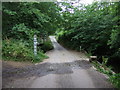
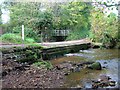
Ford on Ridge Lane
Over Roxby Beck.
Footbridge available to the left.
Image: © JThomas
Taken: 26 Jul 2015
0.03 miles
4
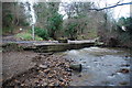
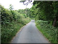
Ford at Dalehouse near Staithes
This ford on the Roxby Beck is found at Dalehouse.
Image: © John Walton
Taken: 4 Jan 2014
0.04 miles
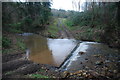
6
Staithes Beck
Roxby Beck and Easington Beck combine at this point, but what should the combined waters be called? The current OS map is no help, but if one goes back to old OS 6" maps, the name 'Staithes Beck' appears here and not just on the approach to the village of that name.
Image: © Gordon Hatton
Taken: 9 Feb 2019
0.05 miles
9

Farmland towards Boulby Mine
Looking across the fields from Staithes.
Image: © JThomas
Taken: 24 Sep 2014
0.18 miles
10
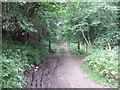
Ford in Dalehouse Wood near Staithes
This ford on the Roxby Beck is found on the track through Dalehouse Wood. There is a further ford on Roxby Beck further upstream on the same track.
Image: © John Walton
Taken: 4 Jan 2014
0.18 miles