IMAGES TAKEN NEAR TO
Westfield Terrace, SALTBURN-BY-THE-SEA, TS13 4PU
Introduction
This page details the photographs taken nearby to Westfield Terrace, TS13 4PU by members of the Geograph project.
The Geograph project started in 2005 with the aim of publishing, organising and preserving representative images for every square kilometre of Great Britain, Ireland and the Isle of Man.

There are currently over 7.5m images from over14,400 individuals and you can help contribute to the project by visiting https://www.geograph.org.uk
Image Map
Images are licensed for reuse under creativecommons.org/licenses/by-sa/2.0
Notes
- Clicking on the map will re-center to the selected point.
- The higher the marker number, the further away the image location is from the centre of the postcode.
Image Listing (52 Images Found)
Images are licensed for reuse under creativecommons.org/licenses/by-sa/2.0
Image
Details
Distance
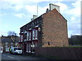
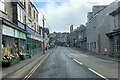
3
Road junction in Loftus, North Yorkshire
Of Zetland Road and Stanon Road.
Image: © James Denham
Taken: 29 Jul 2014
0.04 miles
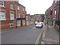
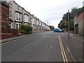
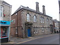
7
Temperance Hall - Zetland Road
Built 1877.
Image: © Betty Longbottom
Taken: 27 Jul 2017
0.06 miles
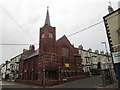
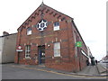
9
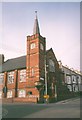
Loftus United Reformed Church
This church has large windows at the side like a school. The basement was presumably built as a Sunday School. There is what looks like a carved stone outside pulpit on the corner of the tower.
Image: © Humphrey Bolton
Taken: Unknown
0.08 miles