IMAGES TAKEN NEAR TO
Wharton Place, SALTBURN-BY-THE-SEA, TS12 3AH
Introduction
This page details the photographs taken nearby to Wharton Place, TS12 3AH by members of the Geograph project.
The Geograph project started in 2005 with the aim of publishing, organising and preserving representative images for every square kilometre of Great Britain, Ireland and the Isle of Man.

There are currently over 7.5m images from over14,400 individuals and you can help contribute to the project by visiting https://www.geograph.org.uk
Image Map
Images are licensed for reuse under creativecommons.org/licenses/by-sa/2.0
Notes
- Clicking on the map will re-center to the selected point.
- The higher the marker number, the further away the image location is from the centre of the postcode.
Image Listing (10 Images Found)
Images are licensed for reuse under creativecommons.org/licenses/by-sa/2.0
Image
Details
Distance
1
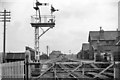
Boosbeck Station
View NE, towards Brotton; ex-NER Middlesbrough - Guisborough - Brotton line. The station closed to passengers on 2/5/60, with the service from Middlesbrough being curtailed to Guisborough, but goods traffic continued through Boosbeck to Brotton until 12/9/64.
Image: © Ben Brooksbank
Taken: 19 Apr 1961
0.11 miles
2
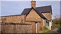
Former Station
The rear of Boosbeck Railway Station, now a private dwelling. The line closed in 1964 and the track was taken up soon after.
Image: © Matthew Hatton
Taken: 9 Feb 2014
0.11 miles
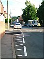
3

Cul de sac in Boosbeck
Geographically this road sign is wrong. Oldham is 110 miles away from Boosbeck!
Image: © Matthew Hatton
Taken: 9 Feb 2014
0.16 miles
4
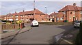
Council Houses in Boosbeck
The Wandhill Estate.
Image: © Matthew Hatton
Taken: 9 Feb 2014
0.16 miles
5
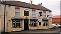
The Station Hotel
Built in latter half of the 19thC, for travellers alighting from the train, wishing to find work in the mines or enjoy the fresh sea air. Now two-tone cream & white.
Image: © Matthew Hatton
Taken: 9 Feb 2014
0.17 miles
6
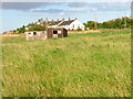
Former Railway Building Used as a Barn, Boosbeck
Image: © Mick Garratt
Taken: 24 Aug 2005
0.19 miles
7
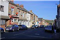
Boosbeck, The Village
View south down the main street of the former mining village.
Image: © Mick Garratt
Taken: 24 Aug 2005
0.19 miles
8
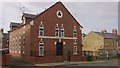
Primitive Methodist Chapel, High Street, Boosbeck
A once large chapel, Methodism was popular in mining areas, it has now been converted into flats, hence the satellite dishes.
Image: © Matthew Hatton
Taken: 9 Feb 2014
0.19 miles
9
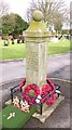
War Memorial in Boosbeck Cementary
This pillar records the names of those servicemen who died in WW2 & in Korea.
Image: © Matthew Hatton
Taken: 9 Feb 2014
0.22 miles