IMAGES TAKEN NEAR TO
Ings Lane, SALTBURN-BY-THE-SEA, TS12 2FT
Introduction
This page details the photographs taken nearby to Ings Lane, TS12 2FT by members of the Geograph project.
The Geograph project started in 2005 with the aim of publishing, organising and preserving representative images for every square kilometre of Great Britain, Ireland and the Isle of Man.

There are currently over 7.5m images from over14,400 individuals and you can help contribute to the project by visiting https://www.geograph.org.uk
Image Map (Loading...)


Getting Data...Please wait
Leaflet Map data © OpenStreetMap
Images are licensed for reuse under creativecommons.org/licenses/by-sa/2.0
Notes
- Clicking on the map will re-center to the selected point.
- The higher the marker number, the further away the image location is from the centre of the postcode.
Image Listing (16 Images Found)
Images are licensed for reuse under creativecommons.org/licenses/by-sa/2.0
Image
Details
Distance
1
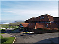
Clubhouse at Hunley Hill Golf Club
Clubhouse and hotel complex, with views to Hummersea Cliff at Skinningrove
Image: © Stephen McCulloch
Taken: 12 Nov 2007
0.01 miles
2
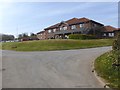
Hunley Hotel
A golf hotel associated with the Hunley Hall Golf Club.
Image: © Oliver Dixon
Taken: 19 Apr 2019
0.02 miles
4

Practice Green & 1st Tee, Hunley Hall Golf Club
Image: © Paul Buckingham
Taken: 22 Aug 2010
0.04 miles
5
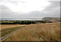
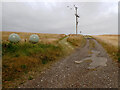
A view from the track to Hunley Hall Farm, Brotton
Image: © habiloid
Taken: 26 Jul 2022
0.04 miles
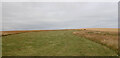
7
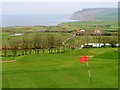
Hunley Hall Golf Course
Overlooking the North Sea with Hummersea Cliff east of Skinningrove in the distance.
Image: © Mick Garratt
Taken: 2 May 2006
0.08 miles
8
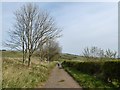
Service track across Hunley Hall Golf Course
A service track with status public footpath crosses the Golf Course from Hunley Hotel to the clifftop
Image: © Oliver Dixon
Taken: 19 Apr 2019
0.09 miles
9

Driving Range, Hunley Hall Golf Club
Image: © Paul Buckingham
Taken: 22 Aug 2010
0.11 miles
10
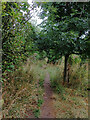
Unmarked path through trees to Ings Lane, Brotton
Image: © habiloid
Taken: 26 Jul 2022
0.12 miles