IMAGES TAKEN NEAR TO
The Fairway, SALTBURN-BY-THE-SEA, TS12 1NQ
Introduction
This page details the photographs taken nearby to The Fairway, TS12 1NQ by members of the Geograph project.
The Geograph project started in 2005 with the aim of publishing, organising and preserving representative images for every square kilometre of Great Britain, Ireland and the Isle of Man.

There are currently over 7.5m images from over14,400 individuals and you can help contribute to the project by visiting https://www.geograph.org.uk
Image Map (Loading...)


Getting Data...Please wait
Leaflet Map data © OpenStreetMap
Images are licensed for reuse under creativecommons.org/licenses/by-sa/2.0
Notes
- Clicking on the map will re-center to the selected point.
- The higher the marker number, the further away the image location is from the centre of the postcode.
Image Listing (40 Images Found)
Images are licensed for reuse under creativecommons.org/licenses/by-sa/2.0
Image
Details
Distance
1
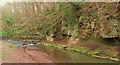
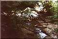
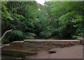
Skelton beck.
A lovely wooded area close to the Cleveland way.
Image: © steven ruffles
Taken: 4 Apr 2015
0.11 miles
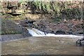
3
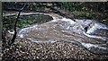
Old weir for Marske Corn Mill
There was a lot of water coming down Skelton Beck this morning tumbling over the ruined weir built to provide a head of water for the long-demolished Marske Corn Mill a few hundred yards downstream. It is interesting that the mill took its name from a village two and a half miles away along the coast and not the nearer one surrounding Skelton Castle which dated from the 12th-century. One reason for this may be that, in the mid-17th century, when a mill was first documented here, Skelton Castle was in ruins, and Marske may have had a far stronger economy with more productive fields. Skelton Beck forms the boundary between the two parishes and the mill was on the Marske side. Access from the Skelton side, as you can see, deep in this gorge, would have been problematic. The ancient fording point of Skelton Beck was a mile upstream below Skelton Castle, where the A1085 is today and where the movement of goods south from the fishing village of Redcar could be observed and controlled. Saltburn, of course, was a new town that developed in the mid-19th-century with the coming of the railway.
From my photo-diary for 17th November 2019 see http://www.fhithich.uk/?p=21903
Image: © Mick Garratt
Taken: 17 Nov 2019
0.13 miles
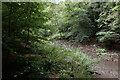
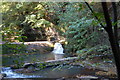
5
Skelton Beck
Deep in Crow Woods the Cleveland Way crosses Skelton Beck, virtually under the 11-arched railway viaduct.
Image: © Graham Horn
Taken: 8 Sep 1999
0.13 miles
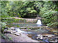
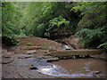
6
Ruined Weir, Skelton Beck
Now breached but once supplied the power to drive Marske Mill.
Image: © Mick Garratt
Taken: 18 Feb 2014
0.13 miles
7
Waterfall at Skelton Beck
Taken from a slightly elevated position.
Image: © Vic Nicholas
Taken: 16 Oct 2006
0.13 miles
9
Skelton Beck
The Saltburn Viaduct is in the background.
Image: © habiloid
Taken: 26 Jul 2022
0.14 miles
10
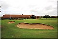
Clubhouse at Saltburn Golf Club
This photograph shows a view of the clubhouse at Saltburn Golf Club. In the foreground of the image, two bunkers next to the 18th Hole can be seen. Viewers with good eye-sight may spot the white golf-ball on the edge of the green - to the right of the chequered flag. The picture was taken looking in an easterly direction towards Bennison Banks.
Image: © Philip Barker
Taken: 19 Jun 2010
0.15 miles