IMAGES TAKEN NEAR TO
Upleatham, REDCAR, TS11 8AG
Introduction
This page details the photographs taken nearby to TS11 8AG by members of the Geograph project.
The Geograph project started in 2005 with the aim of publishing, organising and preserving representative images for every square kilometre of Great Britain, Ireland and the Isle of Man.

There are currently over 7.5m images from over14,400 individuals and you can help contribute to the project by visiting https://www.geograph.org.uk
Image Map
Images are licensed for reuse under creativecommons.org/licenses/by-sa/2.0
Notes
- Clicking on the map will re-center to the selected point.
- The higher the marker number, the further away the image location is from the centre of the postcode.
Image Listing (8 Images Found)
Images are licensed for reuse under creativecommons.org/licenses/by-sa/2.0
Image
Details
Distance
1
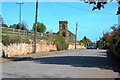
Upleatham
The "High Street". The church is now a private residence.
Image: © Mick Garratt
Taken: 22 Apr 2009
0.04 miles
2
Post box and telephone kiosk in Upleatham
This photograph shows a view of the posting box and telephone kiosk in the small village of Upleatham. Park House and High Park Plantation can just be seen on the horizon in the centre of the image. The picture was taken looking in a south-easterly direction towards A173 road near Duck Hill.
Image: © Philip Barker
Taken: 17 Jun 2010
0.04 miles
3
Wesleyan Methodist Chapel, Upleatham
A small simple chapel building with rather narrow windows. 'Erected 1862' over the door.
Image: © Humphrey Bolton
Taken: 2 Aug 2020
0.05 miles
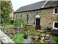
4
War Memorial, Upleatham
The building behind housed the public well. It has since been blocked up.
Image: © Mick Garratt
Taken: 22 Apr 2009
0.09 miles
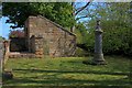
5
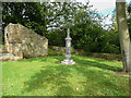
Peace Memorial and Well House, Upleatham
The memorial is made of polished grey granite. It was originally in St Andrew's churchyard but was moved here to keep the well house company.
Image: © Humphrey Bolton
Taken: 2 Aug 2020
0.10 miles
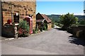
6
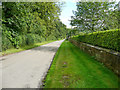
Lane down to the B1268, Upleatham
This used to the main road, which came through the village before the bypass was constructed sometime between 1894 and 1915.
Image: © Humphrey Bolton
Taken: 2 Aug 2020
0.11 miles
7
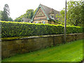
Decorative gable on Upleatham Hall
Upleatham Hall was a 17C house, but was damaged by mining subsidence in 1897 and had to be demolished. The present house was built in the late 20C and the decorative frieze was obtained elsewhere and not from the old house.
Image: © Humphrey Bolton
Taken: 2 Aug 2020
0.12 miles
8
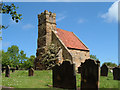
Upleatham Church
Reputedly the smallest church in England
Image: © Alison Stamp
Taken: 30 May 2005
0.15 miles