
IMAGES TAKEN NEAR TO
Tod Point Road, REDCAR, TS10 5BQ
Introduction
This page details the photographs taken nearby to Tod Point Road, TS10 5BQ by members of the Geograph project.
The Geograph project started in 2005 with the aim of publishing, organising and preserving representative images for every square kilometre of Great Britain, Ireland and the Isle of Man.

There are currently over 7.5m images from over14,400 individuals and you can help contribute to the project by visiting https://www.geograph.org.uk
Image Map
Images are licensed for reuse under creativecommons.org/licenses/by-sa/2.0
Notes
- Clicking on the map will re-center to the selected point.
- The higher the marker number, the further away the image location is from the centre of the postcode.
Image Listing (33 Images Found)
Images are licensed for reuse under creativecommons.org/licenses/by-sa/2.0
Image
Details
Distance
1
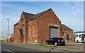
Former St Marys Church, Warrenby
Built in 1953 but was only open until 1978.
Now in commercial use.
Warrenby was once a thriving community, but is now only commercial.
Image: © JThomas
Taken: 23 Feb 2019
0.01 miles
2

Business premises in Tor Point Road, Warrenby
Image: © Peter Robinson
Taken: 30 Oct 2011
0.01 miles
3
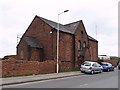
Former church at Warrenby
Former church on Tod Point Road.
Warrenby nowadays consists of little more than scrapyards and industrial units, but was once a thriving community.
Image: © Stephen McCulloch
Taken: 24 Apr 2007
0.02 miles
5
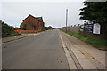
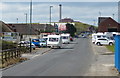
Tod Point Road, Warrenby
This photograph shows a view of a section of Tod Point Road in Warrenby. The road runs between Tod Point (behind the photographer) and York Road in Redcar (ahead). The spire of Redcar Church can just be seen in the right-hand side of the picture; the railway bridge over the (now disused) railway is also visible. The picture was taken looking in a easterly direction towards Redcar Central Station.
Image: © Philip Barker
Taken: 14 Aug 2010
0.05 miles
6
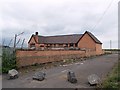
Former school at Warrenby
Another survivor at the ghost town of Warrenby.
This former school is now an industrial unit
Image: © Stephen McCulloch
Taken: 24 Apr 2007
0.05 miles
7

The Teesdale Way approaching Tod Point Road, Warrenby, from Coatham Marsh SSSI Nature Reserve, Redcar
Image: © habiloid
Taken: 25 Apr 2025
0.06 miles
8
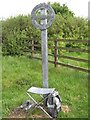
Teesdale Way sculpture
Erected in Coatham Marsh Nature Reserve near Redcar at the eastern end of the Way which runs through the River Tees Valley from Cross Fell in the North Pennines
Image: © Peter Robinson
Taken: 30 May 2009
0.07 miles
10
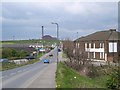
Tod Point Road
Looking west from the old railway bridge
Image: © Stephen McCulloch
Taken: 24 Apr 2007
0.08 miles