IMAGES TAKEN NEAR TO
Elder Grove, REDCAR, TS10 2SR
Introduction
This page details the photographs taken nearby to Elder Grove, TS10 2SR by members of the Geograph project.
The Geograph project started in 2005 with the aim of publishing, organising and preserving representative images for every square kilometre of Great Britain, Ireland and the Isle of Man.

There are currently over 7.5m images from over14,400 individuals and you can help contribute to the project by visiting https://www.geograph.org.uk
Image Map
Images are licensed for reuse under creativecommons.org/licenses/by-sa/2.0
Notes
- Clicking on the map will re-center to the selected point.
- The higher the marker number, the further away the image location is from the centre of the postcode.
Image Listing (9 Images Found)
Images are licensed for reuse under creativecommons.org/licenses/by-sa/2.0
Image
Details
Distance
2
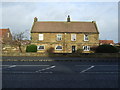
Wheatlands Farm pub
A Fayre & Square family pub restaurant.
Image: © JThomas
Taken: 25 Jan 2014
0.16 miles
3
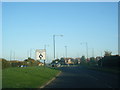
Roundabout near The Ings
This photograph shows a view of a roundabout on Redcar Road (from where the photograph was taken). Greenstones Road joins the roundabout from the left and Kirkwood Drive comes in from the right. Redcar road continues on the opposite side of the roundabout. The picture was taken looking in an east-north-easterly direction towards Long Beck.
Image: © Philip Barker
Taken: 12 Jun 2010
0.22 miles
4
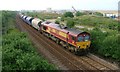
EWS 66179 Passes Under Black's Bridge Bound for Boulby Potash Mine
Image: © Mick Garratt
Taken: 16 Aug 2006
0.23 miles
5
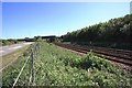
Road and rail near Black's Bridge
This photograph shows a view of a section of the railway that runs between Middlesbrough and Saltburn-by-the-Sea. Green Lane can be seen running alongside the railway track on the opposite side of the fence. The picture was taken looking in a south-south-easterly direction towards Black's Bridge - both the footbridge and the road bridge are visible.
Image: © Philip Barker
Taken: 12 Jun 2010
0.24 miles
6
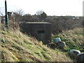
Pillbox, Black's Bridge
Beside the Middlesbrough to Saltburn Railway.
Image: © JThomas
Taken: 25 Jan 2014
0.24 miles
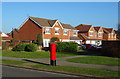
7
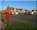
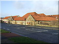
Houses on Cranbourne Drive, Redcar
Showing position of Postbox No. TS10 609.
See Image] for postbox.
Image: © JThomas
Taken: 23 Feb 2019
0.25 miles
8
Houses on Sheerness Way , Redcar
Showing position of Postbox No. TS10 601.
See Image] for postbox.
Image: © JThomas
Taken: 23 Feb 2019
0.25 miles