IMAGES TAKEN NEAR TO
Fraddon, ST. COLUMB, TR9 6PQ
Introduction
This page details the photographs taken nearby to TR9 6PQ by members of the Geograph project.
The Geograph project started in 2005 with the aim of publishing, organising and preserving representative images for every square kilometre of Great Britain, Ireland and the Isle of Man.

There are currently over 7.5m images from over14,400 individuals and you can help contribute to the project by visiting https://www.geograph.org.uk
Image Map
Images are licensed for reuse under creativecommons.org/licenses/by-sa/2.0
Notes
- Clicking on the map will re-center to the selected point.
- The higher the marker number, the further away the image location is from the centre of the postcode.
Image Listing (16 Images Found)
Images are licensed for reuse under creativecommons.org/licenses/by-sa/2.0
Image
Details
Distance
2
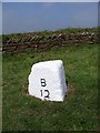
Old Milestone by Fraddon Hill, Fraddon
Carved stone post by the UC road (was A30), in parish of ST ENODER (RESTORMEL District), Fraddon, opposite "Madison Place", in bus stop lay-by, on grass, on West side of road. BT tombstone, erected by the Bodmin turnpike trust in the 19th century.
Inscription reads:-
: B / 12 : : T / 16 (12) : : 16 (was faint) :
Grade II listed.
List Entry Number: 1393899 https://historicengland.org.uk/listing/the-list/list-entry/1393899
Milestone Society National ID: CW_BMTO12o.
Image: © Ian Thompson
Taken: Unknown
0.06 miles
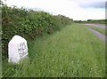
3
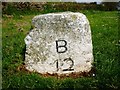
Old Milestone by the former A30, Fraddon
Carved stone post by the UC road (was A30), in parish of ST ENODER (RESTORMEL District), Fraddon, opposite "Madison Place", in bus stop lay-by, on grass, on North side of road. 'BT' tombstone, erected by the Bodmin turnpike trust in the 19th century.
Inscription reads:-
: B / 12 : : (T / 12¼) :
Grade II listed.
List Entry Number: 1393899 https://historicengland.org.uk/listing/the-list/list-entry/1393899
Milestone Society National ID: CW_BMTO12o.
Image: © Rosy Hanns
Taken: 11 Apr 2019
0.06 miles
4
Parka Road entering Fraddon
The road from St Columb Road descends towards Fraddon with the spoil heap west of Wheal Remfry China Clay Pit in the background (in Image).
Image: © Derek Harper
Taken: 8 Jun 2010
0.14 miles
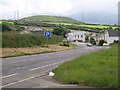
5
Milestone by Parka Road
A listed milestone described at "probably C18" at http://www.britishlistedbuildings.co.uk/en-71310-milestone-at-sw-912586-st-enoder , showing 3 miles to St Columb.
Image: © Derek Harper
Taken: 8 Jun 2010
0.15 miles
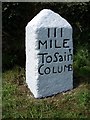
6
Old Milestone by the former A39, Parka Road, north of Fraddon
Carved stone post by the UC road (was A39), in parish of ST ENODER (RESTORMEL District), just North of Fraddon by Parka Road, on brow of hill, on West side of road. St Columb stone, erected by the Camelford, Wadebridge & St Columb turnpike trust in the 18th century.
Inscription reads:-
III
MILE
To Saint
COLUMB
Grade II listed.
List Entry Number: 1144055 https://historicengland.org.uk/listing/the-list/list-entry/1144055
Milestone Society National ID: CW_SCMT03.
Image: © Rosy Hanns
Taken: 11 Apr 2019
0.16 miles
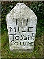
7
Old Milestone by the former A39, Parka Road, north of Fraddon
Carved stone post by the UC road (was A39), in parish of ST ENODER (RESTORMEL District), just North of Fraddon by Parka Road, on brow of hill, on West side of road. St Columb stone, erected by the Camelford, Wadebridge & St Columb turnpike trust in the 18th century.
Inscription reads:-
III
MILE
To Saint
COLUMB
Grade II Listed. List Entry Number:1144055
https://historicengland.org.uk/listing/the-list/list-entry/1144055
Milestone Society National ID: CW_SCMT03.
Image: © Ian Thompson
Taken: 10 Dec 2017
0.16 miles
9
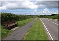
Parka Road
With a wide verge, the road from Fraddon passes a seat and begins to drop towards St Columb Road. The chimney of the Parka mine can be seen over the hedge just right of the seat.
Image: © Derek Harper
Taken: 8 Jun 2010
0.17 miles