IMAGES TAKEN NEAR TO
Chapel Rock Close, PERRANPORTH, TR6 0FL
Introduction
This page details the photographs taken nearby to Chapel Rock Close, TR6 0FL by members of the Geograph project.
The Geograph project started in 2005 with the aim of publishing, organising and preserving representative images for every square kilometre of Great Britain, Ireland and the Isle of Man.

There are currently over 7.5m images from over14,400 individuals and you can help contribute to the project by visiting https://www.geograph.org.uk
Image Map
Images are licensed for reuse under creativecommons.org/licenses/by-sa/2.0
Notes
- Clicking on the map will re-center to the selected point.
- The higher the marker number, the further away the image location is from the centre of the postcode.
Image Listing (4 Images Found)
Images are licensed for reuse under creativecommons.org/licenses/by-sa/2.0
Image
Details
Distance
2
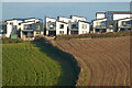
Farmland and houses, Perranzabuloe
Cramped modern houses on the southern edge of Perranporth reflect a style of architecture currently popular in the area. They are seen across a valley from Coombe View.
Image: © Andrew Smith
Taken: 12 Feb 2023
0.06 miles
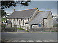
4
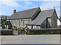
The Church of St Michael at Perranporth
Viewed from the south-east.
Image: © Peter Wood
Taken: 3 May 2017
0.25 miles