IMAGES TAKEN NEAR TO
Hendrawna Lane, PERRANPORTH, TR6 0DE
Introduction
This page details the photographs taken nearby to Hendrawna Lane, TR6 0DE by members of the Geograph project.
The Geograph project started in 2005 with the aim of publishing, organising and preserving representative images for every square kilometre of Great Britain, Ireland and the Isle of Man.

There are currently over 7.5m images from over14,400 individuals and you can help contribute to the project by visiting https://www.geograph.org.uk
Image Map
Images are licensed for reuse under creativecommons.org/licenses/by-sa/2.0
Notes
- Clicking on the map will re-center to the selected point.
- The higher the marker number, the further away the image location is from the centre of the postcode.
Image Listing (7 Images Found)
Images are licensed for reuse under creativecommons.org/licenses/by-sa/2.0
Image
Details
Distance
1
Flood Channel
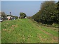
This grassy area between the stream, which is underneath the bushes, and the road to the left would take flood water in the event of extreme rainfall. Presumably before the road was built and the valley bottom was drained there was marshland here which would have performed the same function without maintenance.
Image: © Tony Atkin
Taken: 15 Oct 2005
0.09 miles
2
Walkers at Perranporth
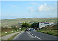
Walkers on the path adjacent to New Road, Perranporth on a wet and windy May morning.
Image: © Kevin Hale
Taken: 21 May 2006
0.11 miles
3
Channel Clearance
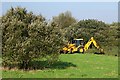
Removing accumulated vegetation and assorted debris from the stream channel with a digger.
Image: © Tony Atkin
Taken: 15 Oct 2005
0.15 miles
4
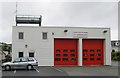
Perranporth Fire Station
Perranporth Fire Station, Station Road, Perranporth, Cornwall. One of a group of Cornish fire stations either replaced or refurbished under the government's Private Finance Initiative (PFI) scheme. This station is on the same site as the earlier fire station, and the corner girders of the original station have been 'wrapped up' in the new building.
Image: © Kevin Hale
Taken: 21 May 2006
0.18 miles
5
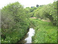
Un-named stream near Nansmellyn
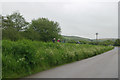
Looking upstream from the bridge in New Road.
Image: © Rod Allday
Taken: 30 May 2012
0.21 miles
6
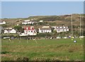
Playing fields below Reen Sands
A Saturday afternoon game of Rugby Football in progress on the valley bottom playing fields at Perranporth. The sand dunes of Reen Sands form the eastern side of this valley beyond the houses.
Image: © Tony Atkin
Taken: 15 Oct 2005
0.22 miles