IMAGES TAKEN NEAR TO
Rose, TRURO, TR4 9PL
Introduction
This page details the photographs taken nearby to TR4 9PL by members of the Geograph project.
The Geograph project started in 2005 with the aim of publishing, organising and preserving representative images for every square kilometre of Great Britain, Ireland and the Isle of Man.

There are currently over 7.5m images from over14,400 individuals and you can help contribute to the project by visiting https://www.geograph.org.uk
Image Map
Images are licensed for reuse under creativecommons.org/licenses/by-sa/2.0
Notes
- Clicking on the map will re-center to the selected point.
- The higher the marker number, the further away the image location is from the centre of the postcode.
Image Listing (4 Images Found)
Images are licensed for reuse under creativecommons.org/licenses/by-sa/2.0
Image
Details
Distance
1
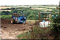
Farm Machinery and Valley
Beyond the farm machinery in the foreground, this shot looks across the valley which bisects this grid square north to south. It is typically wooded on the steep slopes and mixed farming on the plateau.
Image: © Tony Atkin
Taken: 4 Aug 2006
0.12 miles
2
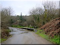
Ford Near Chalcotts Farm
This ford is on the minor road between Rose and Rejerra and is just downstream of Wheal Hope.
Image: © Nigel Mykura
Taken: 1 Mar 2016
0.14 miles
3
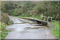
Ford near Chalcott's Farm
Over a small stream which flows eventually to the sea at Holywell Bay. To the locals, this ford is known as Tommascotty which roughly translates as "house in the wooded valley by the stream" (thanks to Simon Glanville for this information).
Image: © Rod Allday
Taken: 10 Nov 2013
0.15 miles
4
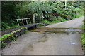
Lower Rose Ford
This ford is found close to Chalacott's Farm.
Image: © John Walton
Taken: 22 Sep 2015
0.15 miles