IMAGES TAKEN NEAR TO
Rose, TRURO, TR4 9PF
Introduction
This page details the photographs taken nearby to TR4 9PF by members of the Geograph project.
The Geograph project started in 2005 with the aim of publishing, organising and preserving representative images for every square kilometre of Great Britain, Ireland and the Isle of Man.

There are currently over 7.5m images from over14,400 individuals and you can help contribute to the project by visiting https://www.geograph.org.uk
Image Map
Images are licensed for reuse under creativecommons.org/licenses/by-sa/2.0
Notes
- Clicking on the map will re-center to the selected point.
- The higher the marker number, the further away the image location is from the centre of the postcode.
Image Listing (8 Images Found)
Images are licensed for reuse under creativecommons.org/licenses/by-sa/2.0
Image
Details
Distance
1
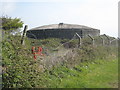
Covered reservoir next to St Piran's Round
Image: © Rod Allday
Taken: 18 Apr 2009
0.05 miles
2
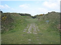
Entrance to St Piran's Round
St Piran's Round is the best surviving example of a plen an gwary - medieval amphitheatre, or playing place. Cornish language miracle plays were enacted in such places in Mid and West Cornwall throughout the Middle Ages. Some believe that this one was constructed solely for this purpose but it does seem likely from its form that it might originally have been an Iron Age or Romano-British enclosure. It is still used for the performance of miracle plays and it has also been used on five occasions in recent years for the staging of the annual Cornish Gorseth.
Image: © Rod Allday
Taken: 18 Apr 2009
0.07 miles
3
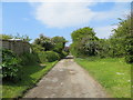
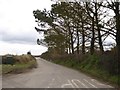
Byway from the B3285 to Rose
Looking north-westward from near St Piran's Roand
Image: © Peter Wood
Taken: 3 May 2017
0.09 miles
4
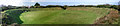
St Piran's Round
Panoramic of the earthwork bank and ditch known as 'St Piran's Round', northwest of Goonhavern, in the village of Rose.
Image: © Alan Simkins
Taken: 21 Oct 2005
0.10 miles
5
The road to Reen Cross
A minor road leading south from the B3285 near St Piran's Round
Image: © David Smith
Taken: 11 Mar 2016
0.11 miles
6
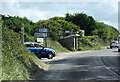
Bus Shelter at Rose Crossroads on B3285 in Cornwall
Image: © Roy Hughes
Taken: 5 Sep 2013
0.12 miles
7
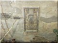
Ordnance Survey Flush Bracket G3488
This bracket can be found on the track-side wall of a house at Rosehill. The benchmark height is recorded as being 90.032 metres above sea level.
For more detail see : http://www.bench-marks.org.uk/bm15415
Image: © Peter Wood
Taken: 3 May 2017
0.13 miles
8
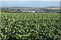
Farmland, Perranzabuloe
Goonhavern is seen over cauliflowers from a byway to the south of Rose.
Image: © Andrew Smith
Taken: 12 Feb 2023
0.16 miles