IMAGES TAKEN NEAR TO
Zelah, TRURO, TR4 9HZ
Introduction
This page details the photographs taken nearby to TR4 9HZ by members of the Geograph project.
The Geograph project started in 2005 with the aim of publishing, organising and preserving representative images for every square kilometre of Great Britain, Ireland and the Isle of Man.

There are currently over 7.5m images from over14,400 individuals and you can help contribute to the project by visiting https://www.geograph.org.uk
Image Map
Images are licensed for reuse under creativecommons.org/licenses/by-sa/2.0
Notes
- Clicking on the map will re-center to the selected point.
- The higher the marker number, the further away the image location is from the centre of the postcode.
Image Listing (8 Images Found)
Images are licensed for reuse under creativecommons.org/licenses/by-sa/2.0
Image
Details
Distance
1

The Old Road up Zelah Hill
The old road did not make a sharp turn left but continued in front of those (now renovated) farm buildings. Just behind that bank on the right is the new road, Image a fact which would be obvious if this picture came with sound.
Image: © Tony Atkin
Taken: 3 Aug 2006
0.03 miles
2
The New Road up Zellah Hill
Just a couple of yards away from Image is all the noise and fumes of a major road, the A30.
Image: © Tony Atkin
Taken: 3 Aug 2006
0.03 miles

4

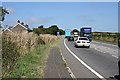
St Allen : A30
The A30 heading through the St Allen parish.
Image: © Lewis Clarke
Taken: 22 Oct 2019
0.07 miles

6
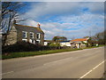
Polstain Farm
Beside the old A30 at Zelah.
Image: © Rod Allday
Taken: 12 Feb 2010
0.16 miles
7
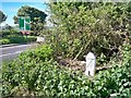
Old Milestone by the A30 at Zelah Hill
Carved stone post by the A30, in parish of ST ALLEN (CARRICK District), Zelah Hill, Mount Pleasant, by the road, on North side of road. Erected by the parish in the 18th century.
Inscription reads:-
: BODMIN / 18M : : 10 / R : : PENZANCE / 28M :
Carved benchmark on left face.
Grade II Listed. List Entry Number: 1141473
https://historicengland.org.uk/listing/the-list/list-entry/1141473
Milestone Society National ID: CW_PZBM28.
Image: © Ian Thompson
Taken: 1 Jul 1996
0.19 miles
8
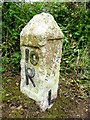
Old Milestone by the A30 at Zelah Hill
Carved stone post by the A30, in parish of ST ALLEN (CARRICK District), Zelah Hill, Mount Pleasant, by the road, on North side of road. Erected by the parish in the 18th century.
Inscription reads:-
: BODMIN / 18M : : 10 / R : : PENZANCE / 28M / L :
Carved benchmark on left face.
Grade II listed.
List Entry Number: 1141473 https://historicengland.org.uk/listing/the-list/list-entry/1141473
Milestone Society National ID: CW_PZBM28.
Image: © Rosy Hanns
Taken: 19 May 2019
0.19 miles