IMAGES TAKEN NEAR TO
TR4 8YA
Introduction
This page details the photographs taken nearby to TR4 8YA by members of the Geograph project.
The Geograph project started in 2005 with the aim of publishing, organising and preserving representative images for every square kilometre of Great Britain, Ireland and the Isle of Man.

There are currently over 7.5m images from over14,400 individuals and you can help contribute to the project by visiting https://www.geograph.org.uk
Image Map
Images are licensed for reuse under creativecommons.org/licenses/by-sa/2.0
Notes
- Clicking on the map will re-center to the selected point.
- The higher the marker number, the further away the image location is from the centre of the postcode.
Image Listing (15 Images Found)
Images are licensed for reuse under creativecommons.org/licenses/by-sa/2.0
Image
Details
Distance
1

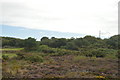
Eden Project advertising hoarding parked in a layby on the A30 near Blackwater, Cornwall
Image: © Steve Fareham
Taken: 21 Aug 2013
0.11 miles
2

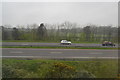
A30 east of Redruth
One of the few sections where the road and the railway run parallel. It must encourage a few car drivers to race the train but we were comfortably overhauling this silver car. Opposite, behind the eastbound lay by, is a triangle of land that formerly contained the junction of the railway to St Agnes. The connection to the main line has been obliterated by the dual carriageway.
This photo was taken from the 1158 Penzance to London Paddington train, having left Redruth at 1231.
Image: © Graham Horn
Taken: 9 Jul 2011
0.14 miles
4
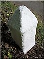
Old Milestone west of Blackwater, St Agnes parish
Carved stone post by the UC road (was A30), in parish of St Agnes (Carrick District), West of Blackwater, by the road, on North side of road. Erected by the parish in the 18th century.
No inscription:-
Two incised faces, one West, one North away from road.
The listing explains the original inscriptions.
Grade II listed.
List Entry Number: 1406160 https://historicengland.org.uk/listing/the-list/list-entry/1406160
Milestone Society National ID: CW_PZBM21
Image: © Ian Thompson
Taken: Unknown
0.17 miles
5
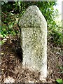
Old Milestone by the former A30
Carved stone post by the UC road (was A30), in parish of ST AGNES (CARRICK District), Southwest of Blackwater, by the road, on North side of road. Erected by the parish in the 18th century.
Inscription reads:-
: (No writing. Two incised faces, one West, one North away from road) :
Grade II listed.
List Entry Number: 1406160 https://historicengland.org.uk/listing/the-list/list-entry/1406160
Milestone Society National ID: CW_PZBM21.
Image: © Rosy Hanns
Taken: 6 Jul 2019
0.17 miles