IMAGES TAKEN NEAR TO
Wheal Henry, TRURO, TR4 8SW
Introduction
This page details the photographs taken nearby to Wheal Henry, TR4 8SW by members of the Geograph project.
The Geograph project started in 2005 with the aim of publishing, organising and preserving representative images for every square kilometre of Great Britain, Ireland and the Isle of Man.

There are currently over 7.5m images from over14,400 individuals and you can help contribute to the project by visiting https://www.geograph.org.uk
Image Map
Images are licensed for reuse under creativecommons.org/licenses/by-sa/2.0
Notes
- Clicking on the map will re-center to the selected point.
- The higher the marker number, the further away the image location is from the centre of the postcode.
Image Listing (14 Images Found)
Images are licensed for reuse under creativecommons.org/licenses/by-sa/2.0
Image
Details
Distance
1
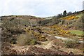
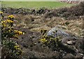
Poldice Valley near Hale Mills
The only road up this valley is an unmetalled track.
Image: © Tony Atkin
Taken: 1 Apr 2006
0.10 miles
2
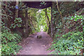
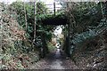
Bridge Supports over long abandoned Railway
A road bridge over the disused railway line that looks like it served the Wheal Maiden Mine near the village of Crofthandy. It is now a footpath and Cycle Track that is popular with walkers and cyclists travelling up from the Bissoe direction.
There are frequent signs of the old railway by the granite blocks to which the rails were fastened.
Image: © Mike Lyne
Taken: 23 Jul 2020
0.13 miles
3
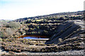
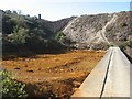
Disused Tailings Pool, Poldice Valley
A small pool, at a lower level than the mail tailings lagoon, which is behind the dam to the right. The water really is that colour, due to the minerals traces left in the mining spoil.
Image: © Graham Loveland
Taken: 16 Feb 2014
0.15 miles
5
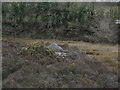
Mine Shaft Cover in the Poldice Valley
This valley was covered in mines in the 19th Century. Now most of the buildings have gone and these conical mesh covers are commonly used to cap the shafts. They give bats access to underground roosting areas.
Image: © Tony Atkin
Taken: 1 Apr 2006
0.17 miles
6
Tramway, now a Bridleway
This is part of a tramway which ran down the western side of the Poldice Valley.
Image: © Tony Atkin
Taken: 1 Apr 2006
0.19 miles
8
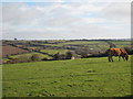
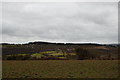
Pasture above the Poldice Valley
Looking towards Cross Lanes.
Image: © Rod Allday
Taken: 19 Nov 2008
0.20 miles
9
Lower tailings dam and lagoon
This is a wonderful location, just west of the tunnels which carry the by-way and river beneath the Chacewater branch of the railway as it crosses the valley. The river, which is in a culvert, emerges into fresh air after passing beneath the tailings lagoons, and the lowest lagoon (dry in this image) is used to regulate water which collects and passes through the upper lagoons. The water which fills this lagoon is loaded with the acidic, iron-rich water which results from the oxidation of sulphide ores. The result is precipitation of iron hydroxides, or ochre, which also carry a toxic mixture of other metals and arsenic from the residual ores in the lagoons. Ochre works were just one of the industries that populated the valley in its mining heyday.
Image: © Jonathan Wilkins
Taken: 20 Sep 2019
0.22 miles
10
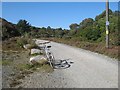
Poldice by-way
This well-maintained track is a by-way leading from Twelveheads to the Poldice Valley, and not part of the National Cycle Route 3, though it does run parallel at this point.
Image: © Jonathan Wilkins
Taken: 20 Sep 2019
0.22 miles